Central PA Hiking Guide: Mount Nittany, Rothrock & State College Trails

Quick Facts
- Location: Centre County (State College area)
- Key Parks: Rothrock State Forest (96,952 acres), Black Moshannon State Park (3,394 acres)
- Terrain: Rocky ridges, mountain bogs, deep valleys
- Top Trails: Mount Nittany (Penn State views), Mid State Trail (wilderness), Bog Trail (unique ecology)
- Unique: Old growth timber, mountain laurel blooms (June), Penn State culture
If you went to Penn State, you know Mount Nittany. But for many people, Central PA is just a blur of farmland on the drive to the stadium. They’re missing out. Just minutes from downtown State College lies Rothrock State Forest, a landscape of rugged ridges and deep valleys that offers some of the best hiking in the state.
This region is the perfect blend of accessibility and wilderness. You can grab a craft coffee in State College, hike a legendary overlook, and then disappear into the “Rocksylvania” backcountry - all before lunch.
Why Hike Central PA?
The defining feature here is the Ridge and Valley landscape. The mountains run in long, parallel lines, creating steep climbs and flat ridge walks. It’s accessible - most trailheads are within 20 minutes of campus - but it’s also serious wilderness.
The “Rocksylvania” nickname is well-earned here. The trails in Rothrock and along the Mid State Trail are notoriously rocky, requiring stiff boots and careful footing. But the rewards are huge: sweeping vistas, solitude, and unique ecosystems like the high-elevation bog at Black Moshannon State Park.
The Trails: Choose Your Central PA Adventure
If You Want the Iconic View: Mount Nittany
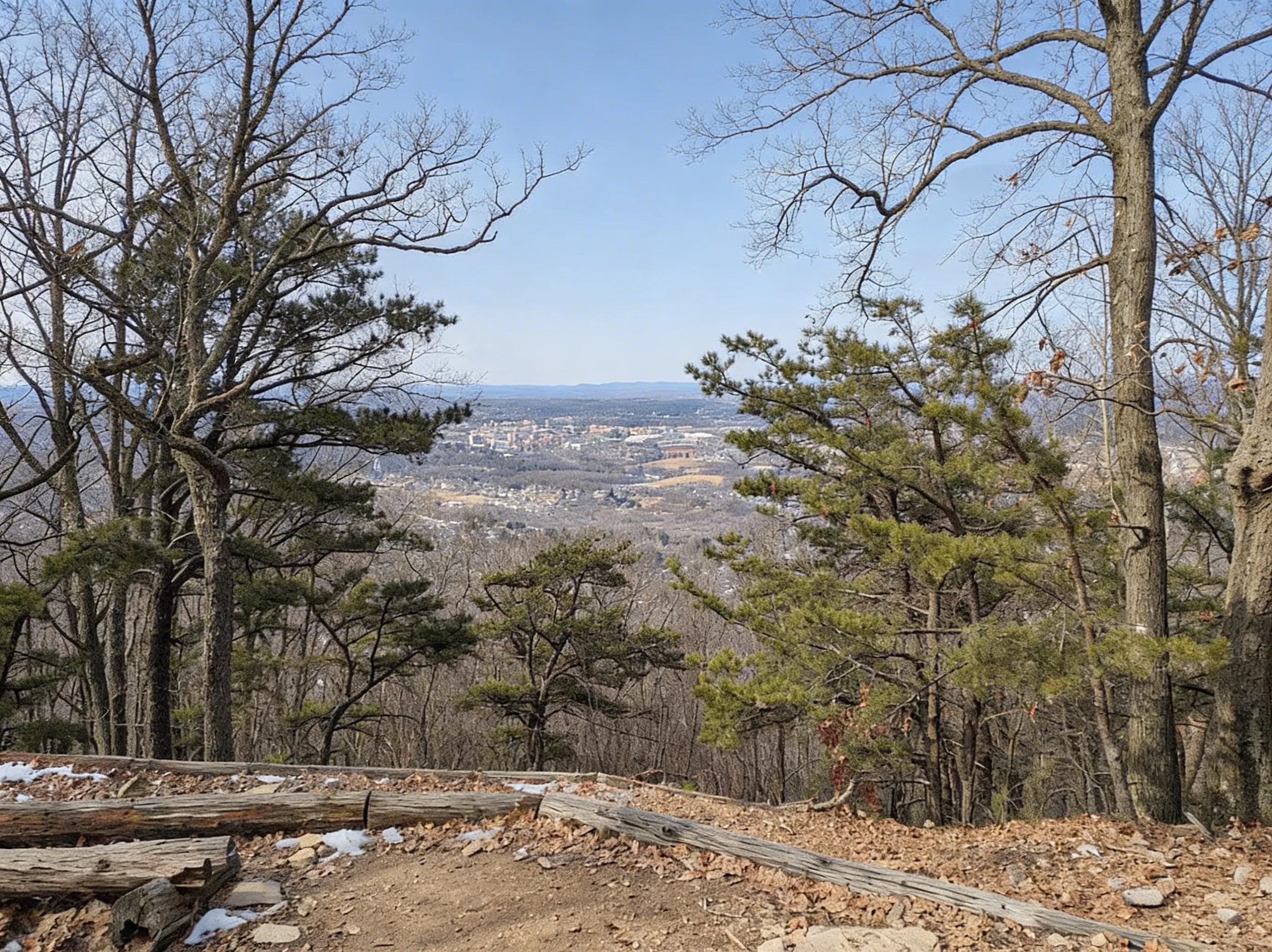
Mount Nittany Loop:
- Distance: 4.6 miles (blue-blazed) or 3.5 miles (white-blazed)
- Elevation: 1,050 ft gain
- Time: 2.5-3.5 hours
- Difficulty: Moderate to strenuous (rocky, steep initial climb)
- Trailhead: Mount Nittany Conservancy parking area (off Route 45)
- Best Time: Fall for foliage (September 25-October 15), spring for wildflowers (April-May)
- The Draw: Mike Lynch Overlook with views of Beaver Stadium, Penn State campus, and Happy Valley
This is the must-do hike of the region. The trail climbs steep, rocky switchbacks to the flat summit of the mountain. From the Mike Lynch Overlook, you get the classic view of the valley that’s on every postcard.
Pro Tip: Avoid football weekends unless you want to hike with 500 tailgaters. If you do go on a game day, start before 9 AM.
If You Want Wilderness: Rothrock State Forest
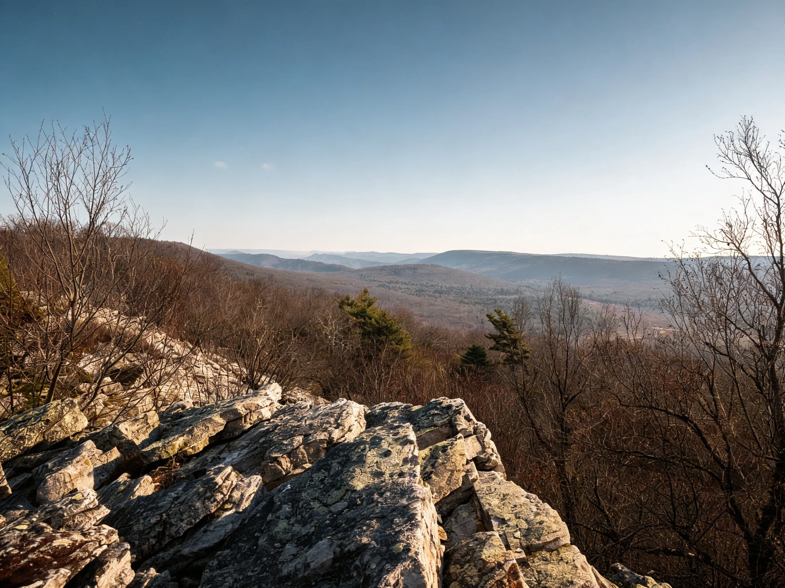
Mid State Trail:
- Distance: 327 miles total (45+ miles through Rothrock)
- Elevation: Varies (constant ups and downs on ridges)
- Time: Multi-day backpacking trip
- Difficulty: Strenuous (rocky, remote, rugged)
- Access: Multiple trailheads (Shingletown Gap, Alan Seeger, Bear Meadows)
- Best Time: Fall (September-October) for foliage, spring (April-May) for cooler temps
- The Draw: The “wildest” trail in PA. Remote ridges, minimal crowds
The MST is the wilder, rockier cousin of the Appalachian Trail. The section through Rothrock follows the ridge tops, offering endless views and ankle-twisting terrain. It’s for serious hikers who want solitude.
Shingletown Gap:
- Distance: 2-6 miles (multiple loop options)
- Elevation: 400-800 ft gain (varies by route)
- Time: 1.5-3 hours
- Difficulty: Moderate
- Trailhead: Shingletown Gap parking area (off Shingletown Road)
- Best Time: Year-round (12 minutes from downtown State College)
- The Draw: Popular local hike with stream-side trails and ridge climbs
Just 12 minutes from downtown, this is where locals go for a quick trail fix. The lower trails follow Roaring Run through hemlock forests, while the upper trails climb the ridge for a workout.
If You Want Unique Ecology: Black Moshannon State Park
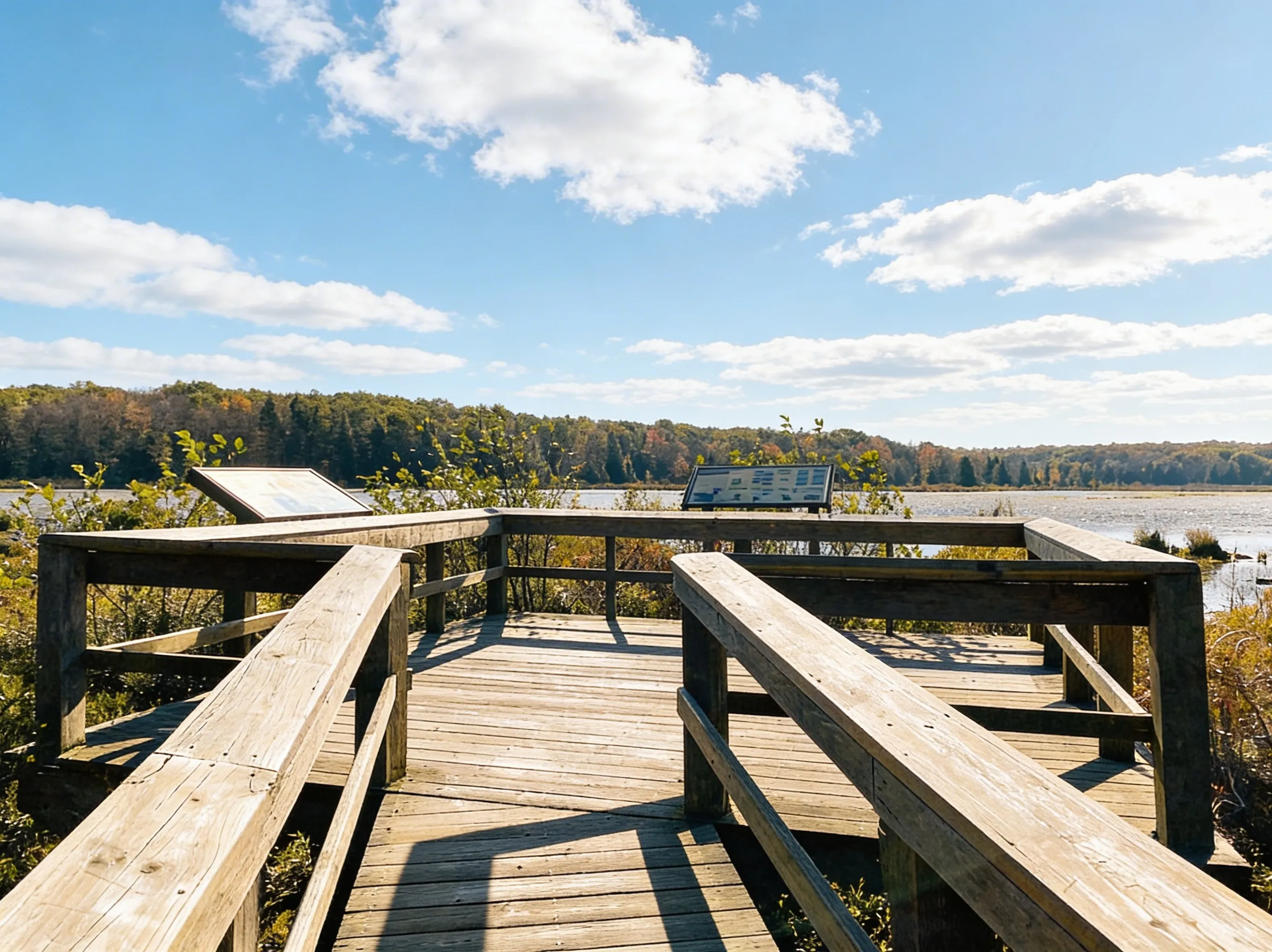
Bog Trail:
- Distance: 1 mile boardwalk loop
- Elevation: Flat (0 ft gain)
- Time: 30-45 minutes
- Difficulty: Easy (accessible, wheelchair-friendly)
- Trailhead: Black Moshannon State Park main parking area
- Best Time: Spring for wildflowers (May-June), summer for dragonflies (July-August)
- The Draw: Unique bog environment with carnivorous plants and tea-colored water
Perched atop the Allegheny Plateau, this park protects a rare mountain bog. The boardwalk trail takes you right over the water, where you can see pitcher plants, sundews, and other bog-loving species.
Allegheny Front Trail:
- Distance: 42-mile loop
- Elevation: 1,200 ft cumulative gain
- Time: 3-4 days (backpacking)
- Difficulty: Moderate to strenuous
- Best Time: Fall (September-October) for foliage
- The Draw: Diverse terrain (bog, stream, vistas) around Black Moshannon
If You Want Old Growth: Bald Eagle State Forest
Snyder-Middleswarth Natural Area:
- Distance: 2-5 miles (multiple trails)
- Elevation: 400-600 ft gain
- Time: 1.5-3 hours
- Difficulty: Moderate
- Trailhead: Snyder-Middleswarth parking area (off Route 45)
- Best Time: Summer for cool shade (June-August), fall for foliage (September-October)
- The Draw: One of the few old growth hemlock forests in PA
In the “Tall Timbers” section, you can walk among hemlocks that are over 300 years old. It’s a quiet, majestic place that feels like stepping back in time.
Mountain Laurel Season: June in Rothrock
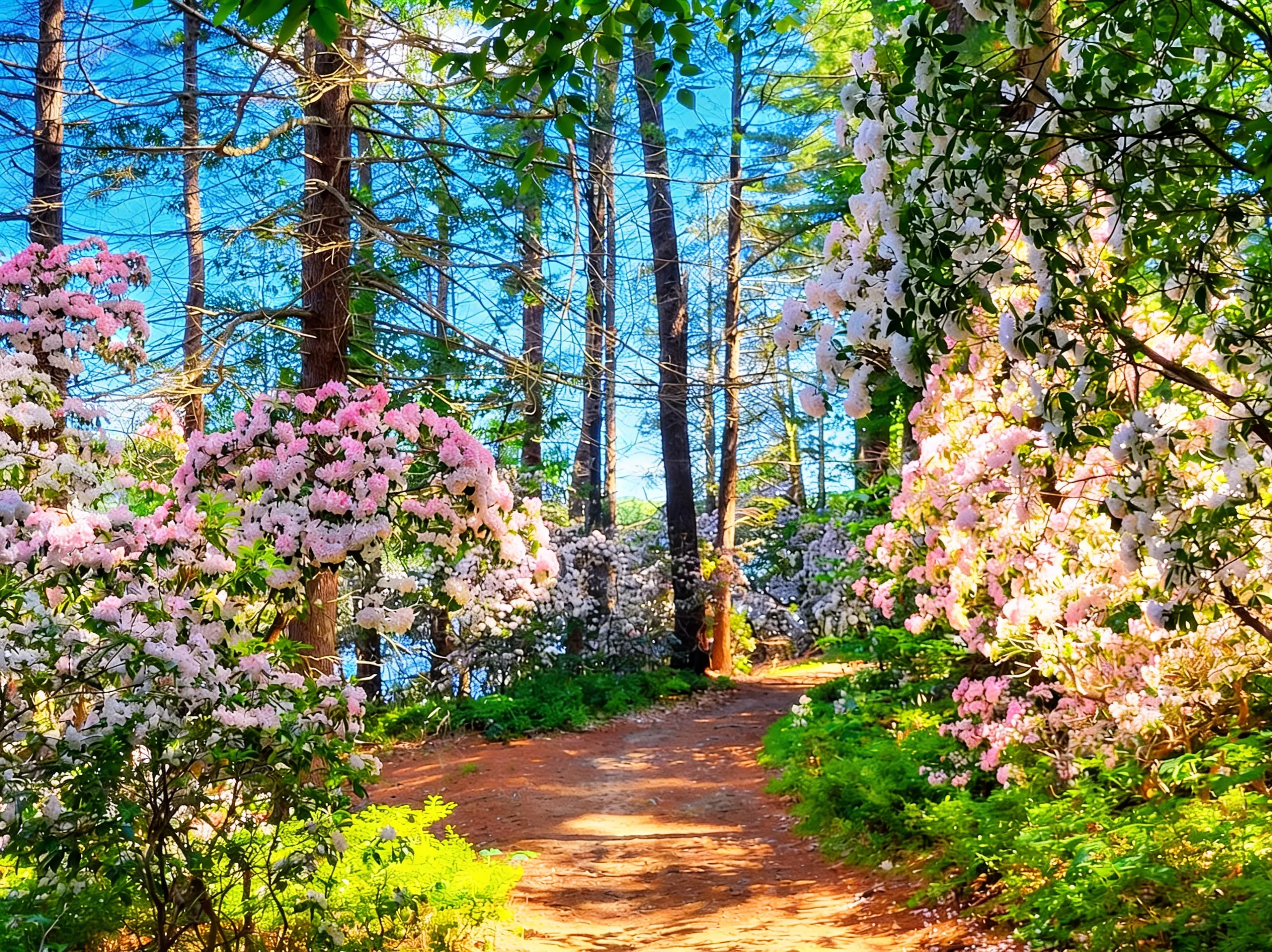
Pennsylvania’s state flower, the mountain laurel, puts on a spectacular show in this region. From early to mid-June, the ridges of Rothrock turn white and pink with blooms.
- Best Spot: The ridges around Shingletown Gap and Cooper’s Gap
- Peak Timing: June 5-20 (varies slightly by elevation and weather)
- Tip: The blooms are worth the drive. Plan a weekend trip just to see them
The Mid State Trail: Pennsylvania’s Wildest Hike
The Mid State Trail (MST) runs for 327 miles from the Maryland border to New York, passing right through the heart of Central PA. It is famously rocky and rugged.
- Why it’s wild: Unlike the AT, there are no shelters (except in a few spots) and fewer road crossings
- Difficulty: Expect slow miles. The rocks will slow you down
- Navigation: It’s blazed orange. You need a map
- Water: Limited sources. Plan carefully
Resource: The Purple Lizard Maps are the gold standard for this region. They are made by locals and show every trail, road, and water source.
Photography Tips
Best Overlook Photography: Mount Nittany Mike Lynch Overlook. Arrive at sunrise (6:30-7:00 AM in summer) for golden hour light on Happy Valley. Wide-angle lens (16-35mm) captures the full valley view.
Best Forest Photography: Snyder-Middleswarth old growth hemlocks. Shoot in overcast conditions for even light. Telephoto lens (70-200mm) isolates individual trees.
Best Seasonal Photography: Mountain laurel blooms in Rothrock (June 5-20). Shoot in early morning or late afternoon for soft light. Macro lens (100mm) captures bloom details.
Best Bog Photography: Black Moshannon Bog Trail. Early morning (7-9 AM) for mist over tea-colored water. Polarizing filter reduces glare.
Camping in Central PA
Developed Campgrounds
Black Moshannon State Park:
- Sites: 80 tent/RV sites, 13 cabins
- Pricing: $19-$35/night (tent sites), $60-$90/night (cabins)
- Booking: Reserve 11 months in advance for summer weekends
- The Draw: Family-friendly, right on the lake
Poe Valley/Poe Paddy State Parks:
- Sites: 70+ rustic sites
- Pricing: $19-$25/night
- The Draw: Deep woods of Bald Eagle State Forest, famous for fishing
Dispersed Camping
You can camp for free in Rothrock and Bald Eagle State Forests, but you must get a free permit from the forest district office.
- Motorized Camping: There are designated sites you can drive to (reservation required)
- Backcountry: You can camp along the trails (like the MST) as long as you follow Leave No Trace principles
What You Need to Know Before You Go
Nearby Hubs
- State College: The hub. Hotels, breweries (Otto’s Pub, Elk Creek Cafe), gear shops (Appalachian Outdoors). Home to Penn State University.
- Bellefonte: Historic Victorian town, 15 minutes from State College. Fly fishing hub on Spring Creek.
- Boalsburg: Gateway to Rothrock, 10 minutes from State College. Pennsylvania Military Museum.
The Rocks
We can’t say it enough: Rothrock is ROCKY. Wear stiff hiking boots, not minimalist trail runners. Trekking poles are highly recommended to save your knees.
Footwear: Stiff-soled boots with ankle support
Poles: Essential for Mid State Trail sections
Pace: Expect 1-1.5 mph on rocky sections (vs. 2-3 mph on smooth trails)
Penn State Football Weekends
In the fall, the entire region transforms on home game weekends.
- Hotels: Book up to a year in advance and prices skyrocket ($200-$400/night)
- Traffic: Route 322 and Atherton Street become parking lots
- Trails: Mount Nittany will be packed. Go early (before 9 AM) or choose a different hike (like Black Moshannon)
- Football Schedule: Check Penn State Athletics for home game dates
Purple Lizard Maps
Don’t rely on Google Maps in the forest. Cell service is spotty at best. Pick up a Purple Lizard Map at Appalachian Outdoors in State College before you head out.
Why they’re essential: Official DCNR maps are outdated. Purple Lizard maps are maintained by local hikers and show every trail, water source, and camping spot.
Best Time to Visit
- Spring (April-May): Wildflowers and cool weather. Trails can be wet. Best dates: April 15-May 15 for wildflowers.
- Summer (June): Mountain Laurel season! It gets hot and humid, but the shaded valleys stay cool. Best dates: June 5-20 for peak blooms.
- Fall (September-October): Peak foliage and football energy. The woods are beautiful, but wear orange (hunting season). Best dates: September 25-October 15 for peak foliage.
- Winter (December-March): Solitude. The ridges get icy, and access roads may not be plowed.
FAQ
Is Mount Nittany hard?
Moderate to strenuous. The hike is short (3.5-4.6 miles) but the climb to the top is steep and rocky (1,050 ft gain).
Can I camp for free in Rothrock?
Yes, but you need a permit for dispersed camping. You can get one from the forest district office.
What’s the best hike near State College?
For views, Mount Nittany. For a quick forest workout, Shingletown Gap. For something unique, the Bog Trail at Black Moshannon.
Is the Mid State Trail well-marked?
It is blazed orange, but sections can be overgrown or tricky. Always carry a map (Purple Lizard) and compass/GPS.
Explore More
Ready to explore Penn State’s backyard wilderness? Start with Mount Nittany for the iconic overlook, tackle the rocky ridges of Rothrock, and discover the unique bog ecology at Black Moshannon.
- Compare this to the Laurel Highlands for longer backpacking on the LHHT
- Check out the PA Grand Canyon for rim hiking and overlooks
- See the full PA State Parks list for more hiking ideas across the state