Lehigh Valley Hiking Guide: AT, D&L Trail & Ridge Scrambles
Quick Facts
- Location: Lehigh & Northampton Counties (Allentown/Bethlehem/Easton)
- Terrain: Flat river walks (D&L) vs. steep, rocky scrambles (AT)
- Best Season: Fall (Raptors at Hawk Mountain, foliage on the ridges)
- Top Draw: Lehigh Gap (the challenge) & D&L Trail (the easy miles)
- Warnings: Glen Onoko is CLOSED. Hunting season requires orange.
You can hike 10 flat miles along a historic canal without breaking a sweat, or you can scramble 900 vertical feet in under a mile on exposed rock that looks like the moon. Welcome to the Lehigh Valley, where the terrain has a split personality and the history runs deep.
Unlike the waterfalls of the Poconos, the Lehigh Valley is defined by its industrial scars and its recovery. You’ll hike past zinc smelting zones turned into wildflower meadows and iron furnace ruins reclaimed by the forest.
Why Hike the Lehigh Valley?
The geography dictates the hiking here. To the north, you have Blue Mountain (the Ridge), home to a notoriously rocky section of the Appalachian Trail. To the south, you have South Mountain, an urban wilderness in the backyard of Allentown and Emmaus. In between, the Lehigh River cuts through, offering miles of flat, scenic rail trails.
This isn’t pristine wilderness. It’s post-industrial ground that Nature has taken back. The views at Lehigh Gap exist because zinc smelting killed the vegetation decades ago. The flat path of the D&L exists because coal trains used to rumble there. It’s rugged, it’s weird, and it’s excellent hiking.
The Trails: Choose Your Pain Level
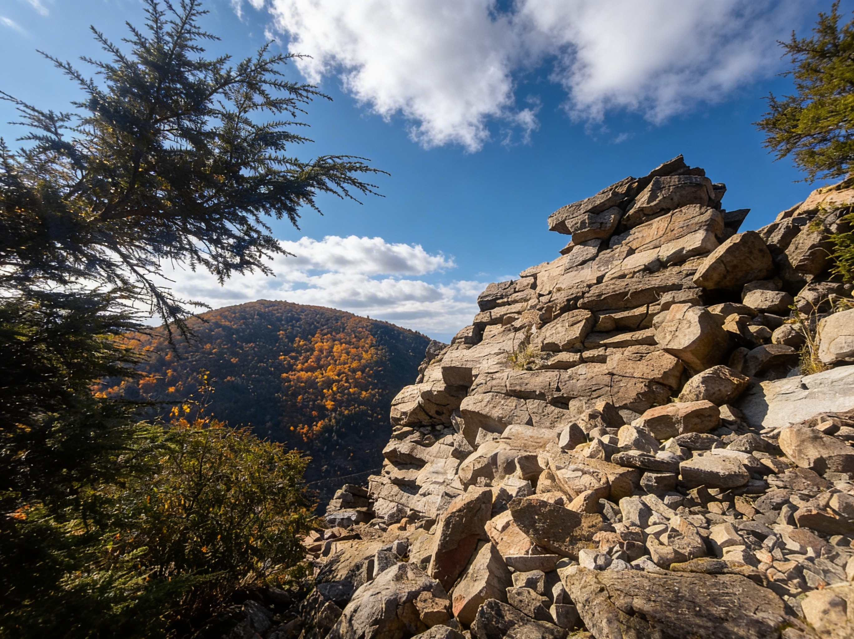
If You Want a Challenge: Lehigh Gap North Trail (Appalachian Trail)
This is one of the hardest sections of the Appalachian Trail in Pennsylvania. You gain 900 feet in less than a mile, and much of it is hand-over-hand scrambling on exposed rocks. The trail climbs the barren, zinc-scarred north face of Blue Mountain.
- Distance: 1.8 miles one-way to summit (3.6 miles round trip)
- Elevation: 900 ft gain
- Time: 2-3 hours round trip
- Difficulty: Strenuous (hand-over-hand scrambling, exposed rock)
- Trailhead: Lehigh Gap Nature Center parking lot (off Route 873)
- The View: 360 degrees. On a clear day, you can see the entire Lehigh Valley and beyond.
- Best Time: Spring for wildflowers on the restoration slopes, fall for cooler temps
- Dogs: Leave them at home for the scramble. It’s not safe for paws.
⚠️ Warning: Do NOT attempt this in rain, ice, or snow. The rocks become lethally slick. This trail exposes you to heights and significant drops. If you have vertigo, pick the South Trail or stick to the D&L below.
If You Want Distance Without Pain: D&L Trail (Delaware & Lehigh National Heritage Corridor)
The Delaware & Lehigh National Heritage Corridor allows you to crush miles without crushing your knees. The full trail is 165 miles long, but the Lehigh Valley section (approx. 50 miles from Allentown to Jim Thorpe) is the sweet spot.
- Distance: 165 miles total (Lehigh Valley section: ~50 miles)
- Elevation: Nearly flat (follows the historic canal and river)
- Time: Variable (most people do 10-20 mile sections)
- Surface: Crushed cinder and gravel. Fast for walking, perfect for gravel bikes.
- Best Sections:
- Allentown to Bethlehem (10 miles): Urban greenway, easy access
- Bethlehem to Easton (12 miles): Historic canal locks, river views
- Walnutport to Lehighton (15 miles): More remote, scenic
- Scenery: It hugs the Lehigh River. The section from Jim Thorpe to White Haven (Lehigh Gorge) is the most scenic, though technically just north of the valley proper.
- Usage: Multi-use. Watch out for cyclists.
- Access: Multiple parking areas along the route. Visit D&L Trail for maps and access points.
If You Want Urban Wilderness: South Mountain Preserve
Located right in Emmaus/Allentown, this preserve makes you feel miles away from the city. Perfect for after-work hikes or weekend trail runs.
- Distance: 20+ miles of trails (various loops)
- Elevation: Moderate. 300-500 ft climbs depending on route
- Time: 1-3 hours depending on loop
- Difficulty: Moderate (rocky, rooty, typical PA terrain)
- Best Trails:
- Swabia Creek Trail: 3.5 miles, creek crossings, moderate
- Spring Creek Trail: 2.5 miles, easier, family-friendly
- Trailheads: Alpine Street (Emmaus), Vera Cruz Road, Spring Creek Road
- Terrain: Rocky (“Gateway to Rocksylvania” applies here too) and wooded.
- Vibe: Local favorite. You’ll see plenty of trail runners and neighbors walking dogs.
If You Want Wildlife: Trexler Nature Preserve
This isn’t your average walk in the woods. The Central Range is home to a herd of bison and elk (fenced, but visible from the trails).
- Distance: 18+ miles of trails across three ranges
- Terrain: Rolling hills, open meadows, steep slate ridges in North Range
- Difficulty: Easy to moderate
- Highlights: Bison and elk viewing, wildflower meadows, forested ridges
- Best Trails:
- Central Range Loop: 3-4 miles, bison/elk viewing
- North Range: Steeper, more challenging, slate ridges
- Access: Multiple parking areas. Free admission.
- Bonus: Adjacent to Lehigh Valley Zoo (separate admission).
- Best Time: Early morning or late afternoon for wildlife viewing.
If You Want Raptors: Hawk Mountain Sanctuary
Hawk Mountain is world-famous for its fall raptor migration. If you want to see eagles, hawks, and falcons, this is the place. Over 20,000 raptors pass through each fall.
- Distance: Various trails (Lookout Trail: 2 miles round trip, River of Rocks: 4 miles round trip)
- Elevation: 300-500 ft gain to overlooks
- Time: 1-3 hours depending on trail
- Difficulty: Moderate (rocky, some steep sections)
- Best Trails:
- Lookout Trail: 2 miles round trip to North Lookout (best raptor viewing)
- River of Rocks Trail: 4 miles, boulder field scramble
- Admission: $10-15 (rare for PA hiking, but supports conservation)
- Best Time: September-November for raptor migration (peak: mid-September for Broad-winged Hawks, November for Golden Eagles)
- Crowds: In October, this place is packed. Go on a weekday or arrive at opening.
- Website: Hawk Mountain Sanctuary for migration forecasts and trail conditions.
If You Want Easy Family Walks: Jacobsburg Environmental Education Center
With 1,000+ acres near Nazareth, Jacobsburg is gentle and historic. Perfect for families and beginner hikers.
- Distance: 18+ miles of trails (various loops)
- Elevation: Minimal to moderate (mostly flat along Bushkill Creek)
- Time: 1-2 hours for most loops
- Difficulty: Easy to moderate
- Best Trails:
- Henry’s Woods Trail: 1.5 miles, old-growth forest loop, easy
- Bushkill Creek Trail: 3 miles, follows the creek, flat
- History: The site of colonial gun manufacturing (Henry family rifle works). You can walk past the history while the kids wade in the creek.
- Access: Free parking at the Environmental Education Center.
- Best Time: Spring for wildflowers, summer for creek wading, fall for foliage.
What You Need to Know Before You Go
Glen Onoko is Closed
We cannot stress this enough: Glen Onoko Falls Trail is permanently closed. The state has removed the parking lot and patrols the area. People have died and been severely injured there. Do not attempt to hike it. If you want waterfalls, drive an hour north to Ricketts Glen.
Hunting Season = Orange Required
Much of the ridge (Blue Mountain) is State Game Lands (SGL 168 and 217). In Pennsylvania, hiking on Game Lands during hunting season (roughly October to January, plus spring gobbler) requires you to wear fluorescent orange. It’s the law, and it’s smart.
The Rocks Are Real
“Rocksylvania” isn’t a joke. The AT section along the ridge is brutal on footwear. Trail runners are fine for the D&L, but if you’re hitting Lehigh Gap or the Ridge, we recommend shoes with rock plates or sturdy boots.
Camping & Lodging
Camping: The Lehigh Valley doesn’t have major campgrounds within the urban core. For camping, head to:
- Hickory Run State Park (30 miles north): 381 sites, electric hookups available, $20-30/night
- Delaware Water Gap NRA (25 miles east): Primitive camping at designated sites
- Dispersed camping: Limited options on State Game Lands (check DCNR regulations)
Lodging: Allentown, Bethlehem, and Easton have extensive hotel options. For a unique stay, consider historic B&Bs in Bethlehem’s downtown or Jim Thorpe (30 miles north).
Nearby: Jim Thorpe (30 miles north) is the outdoor recreation hub with bike rentals, rafting outfitters, and trail access to Lehigh Gorge State Park.
Best Time to Hike
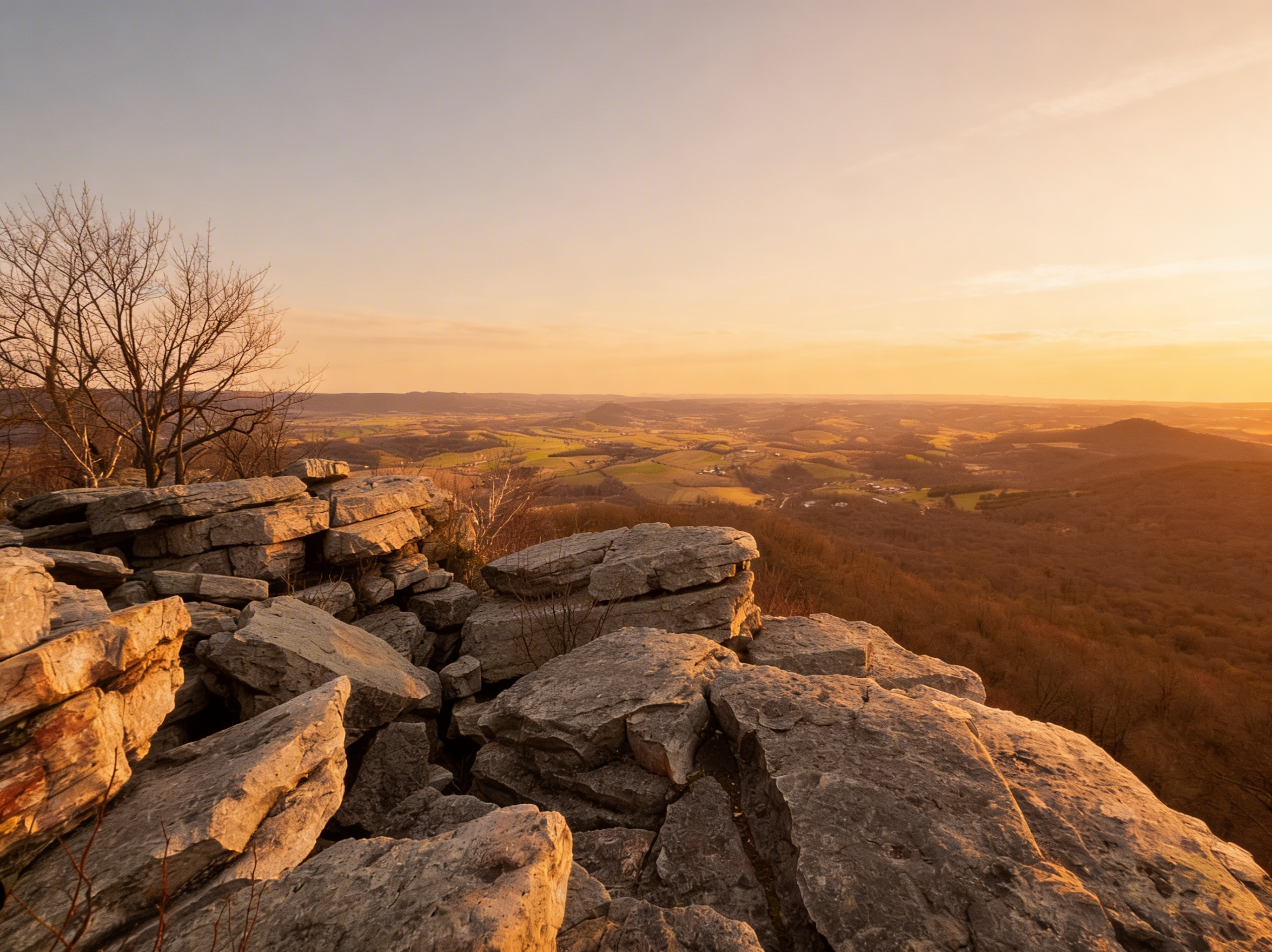
- Fall (Best for Raptors & Foliage): The peak. Raptors at Hawk Mountain (September-November, peak mid-September for Broad-winged Hawks, November for Golden Eagles), foliage turning the ridges red and orange (typically mid-October, peak around October 10-20), and cool air makes the scrambles bearable. Book Hawk Mountain early for weekends.
- Spring (Best for Wildflowers): The Lehigh Gap’s restoration efforts mean wildflowers bloom on the rocky slopes (late April to May). The D&L is perfect for long walks without summer heat.
- Summer (Best for D&L Trail): It gets hot and humid in the valley. Stick to the shaded D&L or hit South Mountain early in the morning. Trexler is great for early morning wildlife viewing.
- Winter (Best for Solitude): Avoid the exposed scrambles (Lehigh Gap) if there’s any chance of ice. The D&L is often hikeable year-round. South Mountain and Jacobsburg are quiet and peaceful.
Photography Tips
Best Scramble Photography: Lehigh Gap North Trail. The barren, zinc-scarred slopes create a unique moonscape. Shoot in late afternoon for dramatic shadows. Spring wildflowers add color to the restoration areas.
Best River Photography: D&L Trail along the Lehigh River. Morning mist rises from the river in fall. The section near Walnutport offers classic river-and-ridge compositions.
Best Raptor Photography: Hawk Mountain North Lookout. Bring a telephoto lens (400mm+) for raptors in flight. Peak migration is mid-September (Broad-winged Hawks) and November (Golden Eagles). Arrive early for the best light and positioning.
Fall Foliage: Blue Mountain ridges peak around October 10-20. Shoot from Lehigh Gap overlook or Hawk Mountain for expansive views. Late afternoon light is best.
Wildlife: Trexler Nature Preserve for bison and elk. Early morning or late afternoon offers the best light and animal activity. Bring a telephoto lens (200mm+).
FAQ
Is hiking free in the Lehigh Valley? Generally, yes. State Parks (Jacobsburg), Nature Centers (Lehigh Gap, Trexler), and the D&L are free. Hawk Mountain is the notable exception with an admission fee.
Where can I see waterfalls? You won’t find major waterfalls in the Lehigh Valley proper. You need to head north to the Poconos for that. Local spots might have small trickles after rain, but nothing like Ricketts Glen.
Are dogs allowed? Yes, on the D&L, South Mountain, and most trails. We strongly recommend against taking dogs on the technical rock scrambles at Lehigh Gap. It’s too dangerous for them.
Explore More
- Visit Lehigh Gap Nature Center for trail maps, restoration info, and Appalachian Trail updates
- Explore the D&L Trail official site for maps, access points, and events
- Check out Hawk Mountain Sanctuary for raptor migration forecasts and trail conditions
- Visit Ricketts Glen State Park for Pennsylvania’s best waterfall hikes (1 hour north)
- Explore the Poconos for more waterfalls and family-friendly trails
- Check out the PA Grand Canyon for another rugged gorge experience
- See the full PA State Parks list for more hiking ideas
Parks in Lehigh Valley Hiking Guide: AT, D&L Trail & Ridge Scrambles
All Trails in Lehigh Valley Hiking Guide: AT, D&L Trail & Ridge Scrambles
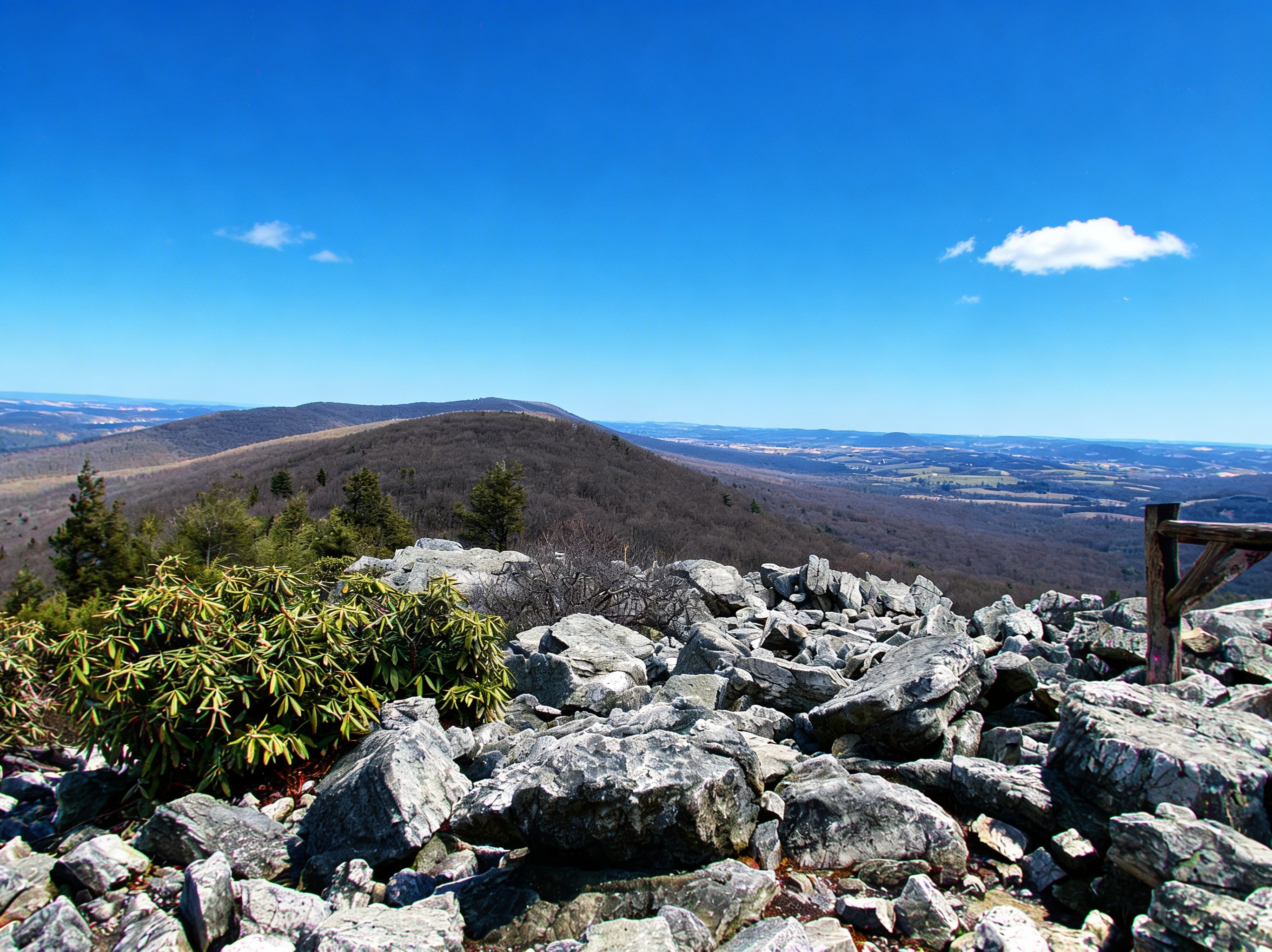
The Pinnacle: Best View in PA (And the Rocks)
270-degree views from The Pinnacle. 9-mile loop with classic rocky AT terrain. The best vista in Pennsylvania.