The Pinnacle: Best View in PA (And the Rocks)
270-degree views from The Pinnacle. 9-mile loop with classic rocky AT terrain. The best vista in Pennsylvania.
Quick Facts
- Distance: 9.0 miles (loop)
- Elevation Gain: 1,300 feet
- Difficulty: Strenuous (length + rocky terrain)
- Highlights: Pulpit Rock, The Pinnacle (270-degree views)
- Blazes: White (Appalachian Trail), Blue (Pinnacle Trail)
- Best For: Experienced hikers asking “Where is the best view in PA?”
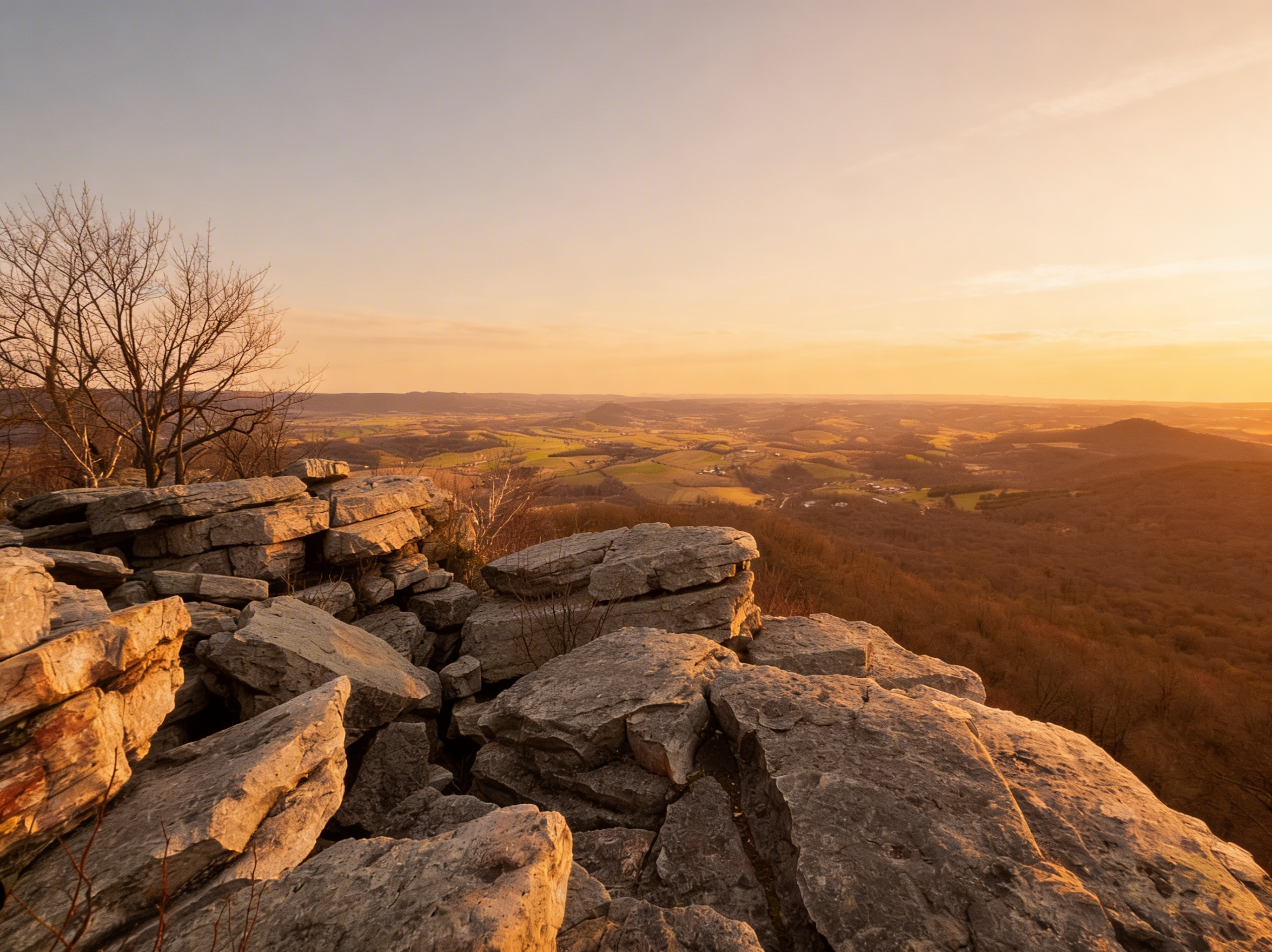
The Pinnacle offers the best view in Pennsylvania. From the massive boulder field at 1,635 feet, you get a 270-degree panorama: the Lehigh Valley sprawls below, the Blue Mountain ridge stretches to the horizon, and on clear days, you can see deep into the Poconos. But you earn it. The 9-mile loop from Hamburg Reservoir climbs 1,300 feet through some of the rockiest terrain on the Appalachian Trail in PA. The section between Pulpit Rock and The Pinnacle is a boulder hop. Your ankles will hate you. The view will make you forget.
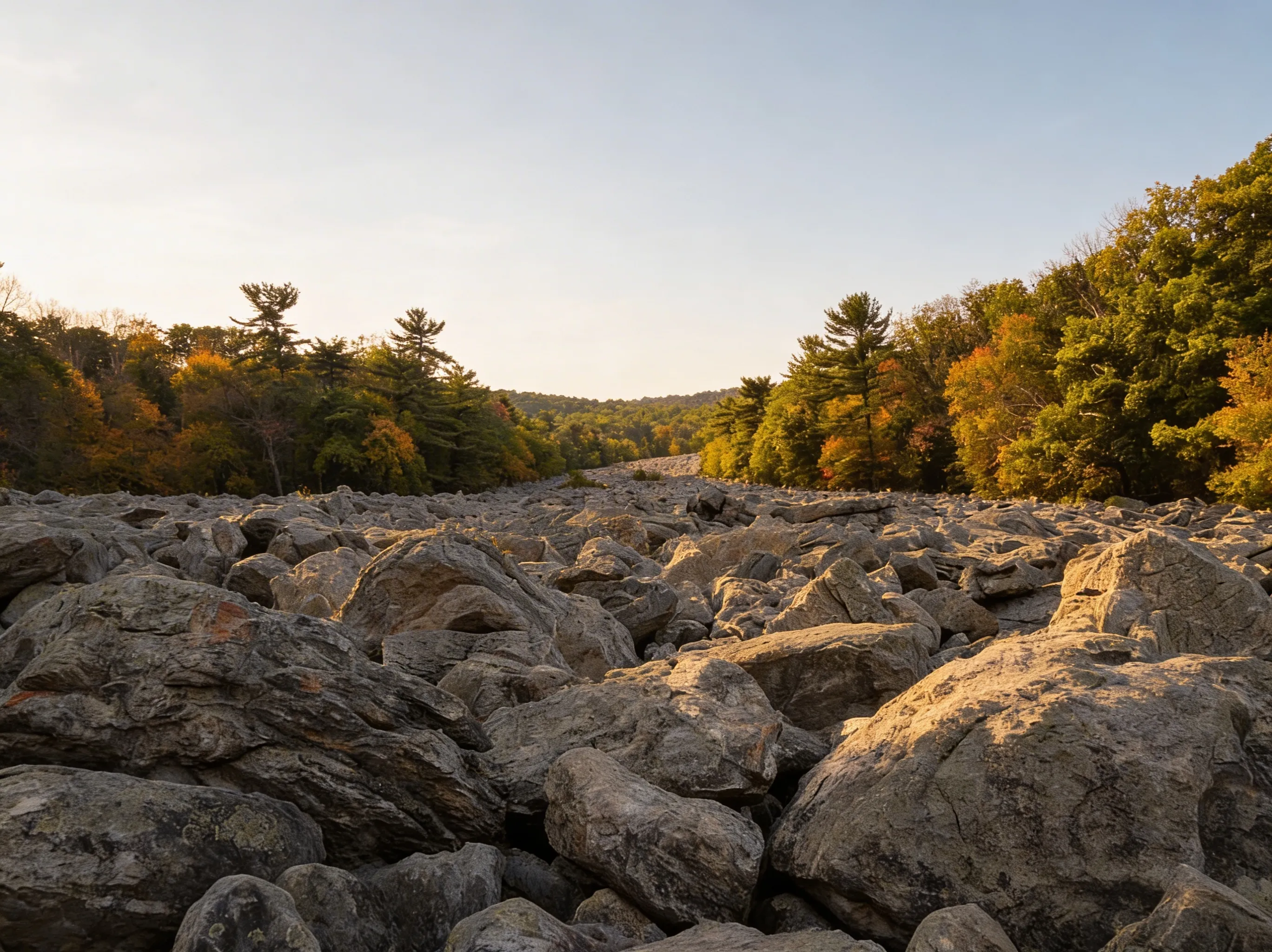 The blue rocks between Pulpit Rock and The Pinnacle.
This section of the AT is managed by PA DCNR’s Weiser State Forest. For current trail conditions and user reviews, check AllTrails.
Pulpit Rock vs. The Pinnacle (What’s the Difference?)
Pulpit Rock (Mile 2.5)
The first major overlook on the loop. It’s a rocky outcrop jutting out from the ridge.
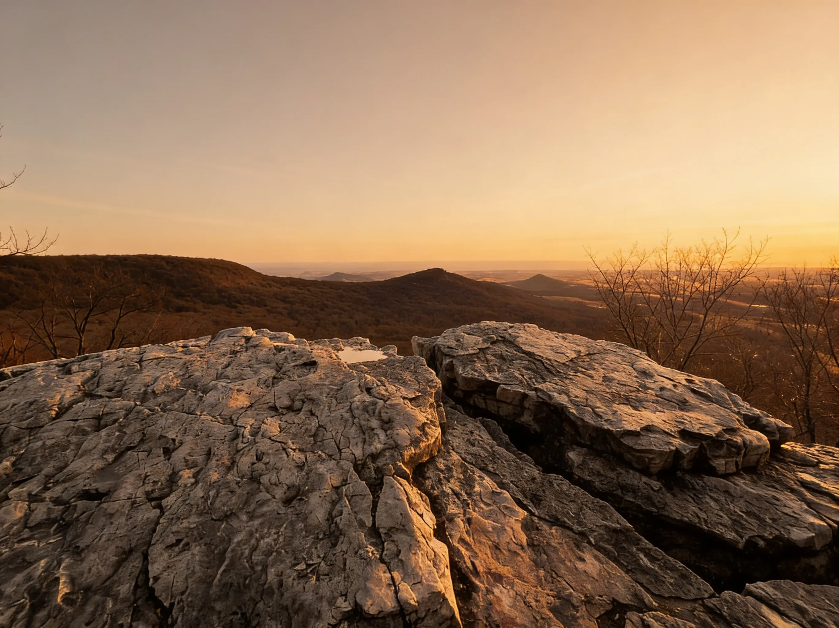 Pulpit Rock.
- The View: Straight down into the Hamburg Reservoir and the valley.
- The Vibe: A great warm-up act. It’s also a prime spot for hawk watching in the fall.
- The Reality: It’s nice, but don’t stop here. The Pinnacle is better.
The Pinnacle (Mile 4.5)
The main event. A massive, flat boulder field at the tip of a geographical “V” in the mountain.
- The View: Expansive 270-degree vista. You feel like you’re standing on the edge of the world.
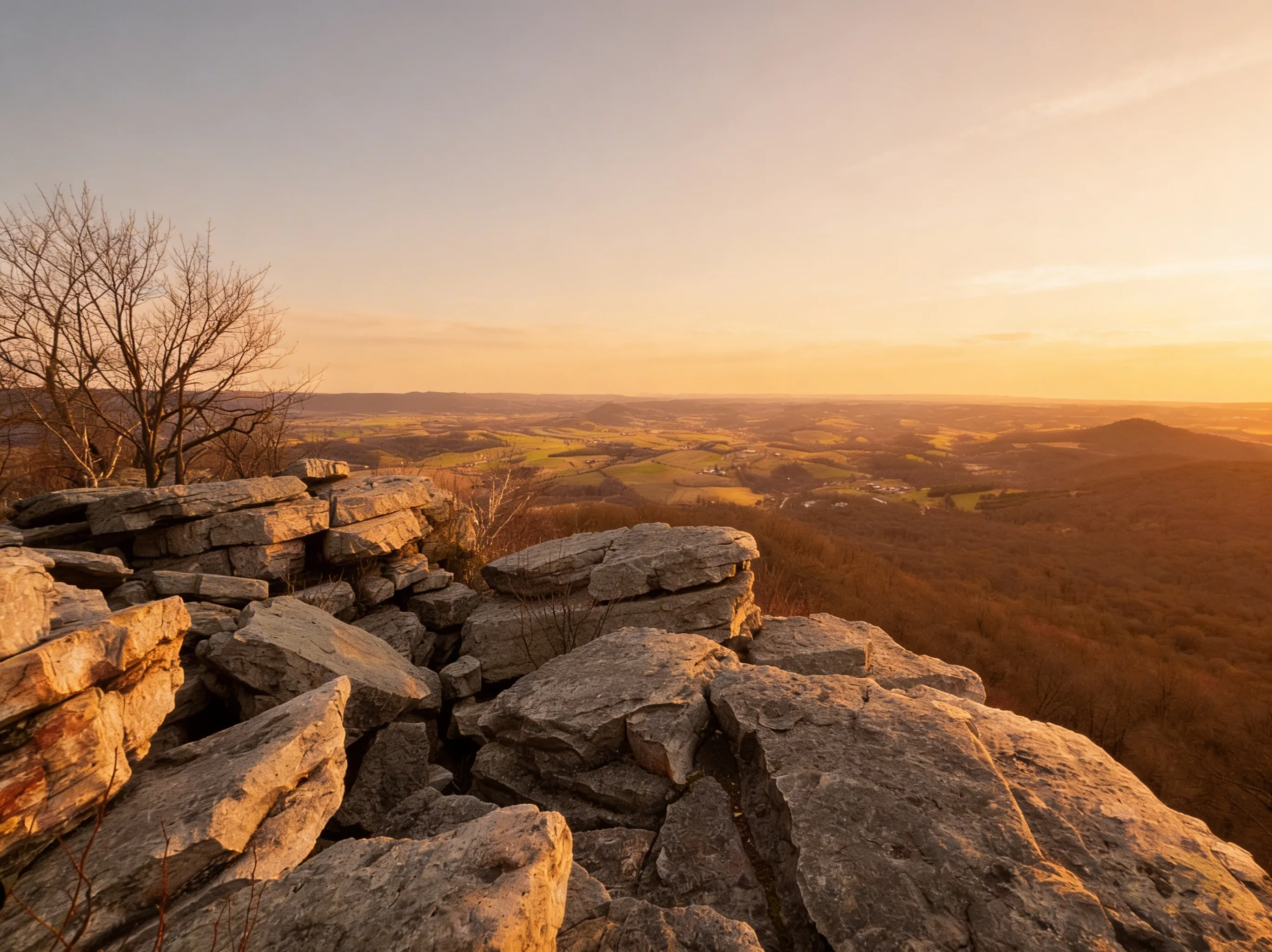 The view from The Pinnacle.
- The Vibe: Epic. This is the place to eat lunch, take photos, and watch hawks and eagles glide below you.
The Loop (Counter-Clockwise Route)
Most hikers do this loop counter-clockwise to get the steep climbing out of the way first.
Start: Hamburg Reservoir to Pulpit Rock (2.5 Miles, 1,000 Feet Up)
From the parking lot, you’ll walk up a gravel road before hitting the white-blazed Appalachian Trail. The climb begins immediately. It’s steep, rocky, and relentless. You are gaining the majority of your elevation here.
Pulpit Rock to The Pinnacle (2 Miles, 300 Feet Up)
This section is classic “Rocksylvania.” The trail follows the ridge, weaving through a minefield of quartzite boulders. You will be watching your feet more than the woods. Trekking poles are highly recommended here to save your knees and ankles.
The Pinnacle to Hamburg Reservoir (4.5 Miles, Mostly Downhill)
After soaking in the view, you’ll pick up the blue-blazed Pinnacle Trail. This follows an old fire road back down to the reservoir. It is long, gradual, and significantly less rocky than the way up. It’s a welcome relief for tired legs.
Parking & Logistics
Hamburg Reservoir Parking
- Location: End of Reservoir Road, Hamburg, PA 19526 (GPS: 40.5658° N, 76.0342° W)
- Capacity: Only holds about 30-40 cars. It is free.
- The Reality: It fills up fast. On nice weekends, arriving after 8:00 AM means you will likely be parking on the road.
- Overflow: Parking on the shoulder of Reservoir Road is common, but ensure you are completely off the pavement and not blocking resident driveways.
Trail Amenities
- Shelter: There’s an AT shelter with a composting toilet near the start of the trail.
- Water: No water sources on the trail. Fill up before you start.
Safety & Hazards
The Rocks (Ankle-Twisters)
⚠️ Warning: The section between the overlooks is brutal on ankles. Wear sturdy hiking boots. Trail runners are risky unless you have strong ankles.
The Edge
⚠️ Warning: The Pinnacle has sheer drop-offs. The rocks can be slippery when wet. Keep kids and dogs back from the edge.
Snakes
⚠️ Warning: Eastern Copperheads and Timber Rattlesnakes are common in this area, especially during warmer months (May-October). Watch where you step and place your hands. If you encounter a snake, give it space and let it move on.
Cell Service
⚠️ Warning: Cell service is spotty to non-existent on the ridge. Download offline maps before you go.
Best Time to Visit
- Fall (Sept-Oct): The foliage from the top is world-class. Plus, it’s peak migration season for hawks and eagles.
- Winter (Dec-Feb): Solitude. The view usually has better clarity due to low humidity. Microspikes are mandatory if there is snow or ice - the rocks become deadly slick.
- Summer: Go early. The ridge is exposed and gets hot.
Explore More
- Lehigh Valley Region
- Hawk Mountain Sanctuary (Note: Hawk Mountain is a paid, private sanctuary nearby, while The Pinnacle is free public land.)

Oscar
Staff Writer
So glad you're here! I'm a lifelong hiker. The trails of this state have shaped who I am — from the waterfalls of the Poconos to the ridgelines of the Laurel Highlands — and in 2024 I started HikingPA to help more people discover what's out there. Whether you're planning your first hike, chasing waterfalls, or just looking for your next adventure in the Keystone State, I hope this becomes the resource you turn to. Thanks for being part of this community — I can't wait to explore Pennsylvania together.