Ferncliff Peninsula: A 2-Mile Time Machine
Touch 300-million-year-old fossils on this easy 2-mile loop. A National Natural Landmark in Ohiopyle.
Quick Facts
- Distance: 1.8-2 miles (loop)
- Difficulty: Easy/Moderate (flat but rocky/rooty)
- Time: 1-1.5 hours
- Unique Feature: 300-million-year-old plant fossils
- Designation: National Natural Landmark (since 1974)
- Best For: Families, geology nerds, photographers
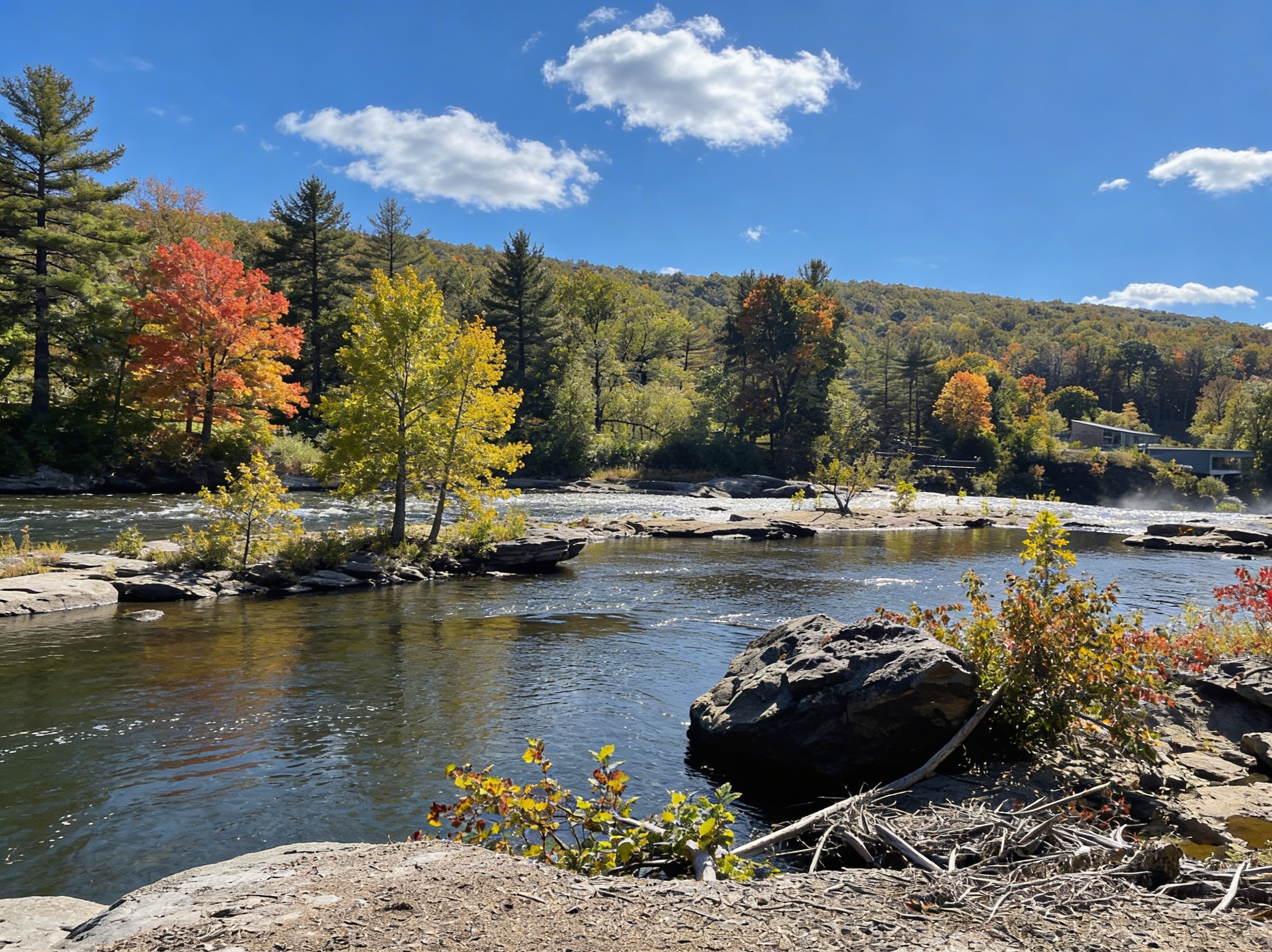
Ferncliff Peninsula is a 2-mile time machine. The sandstone bedrock at the river’s edge is covered in 300-million-year-old plant fossils - remnants of a tropical swamp that existed before dinosaurs. You can touch them. The trail loops around a peninsula created by a horseshoe bend in the Youghiogheny River, which traps seeds from upstream and creates a botanical ecosystem unique to this spot. It’s flat, easy, and designated a National Natural Landmark. This is how to find the fossils.
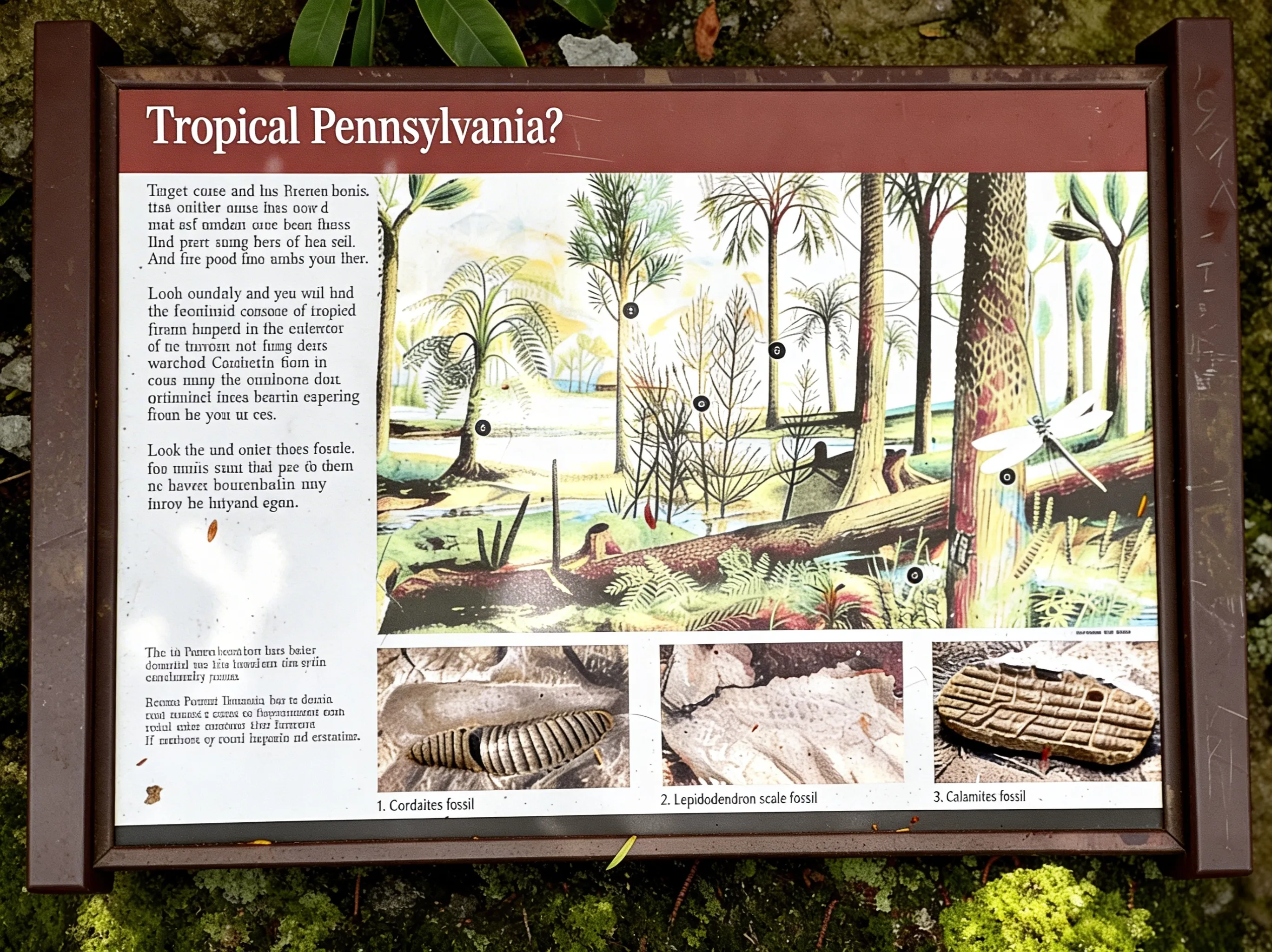 Tropical Pennsylvania 300 million years ago.
Located in Ohiopyle State Park, the Ferncliff Natural Area is accessible via the Great Allegheny Passage (GAP) between the Low and High Bridges. For current trail conditions, check AllTrails.
What Makes Ferncliff Special (National Natural Landmark)
The Fossils (300 Million Years Old)
The main draw here isn’t just the river views - it’s the ground beneath your feet. The sandstone bedrock, especially on the downstream eastern side, is imprinted with fossils from the Carboniferous period.
- Lepidodendron: “Scale trees” that look like snake skin.
- Cordaites: Early ancestors of conifers with strap-like leaves.
- Calamites: Giant horsetails that grew 100 feet tall.
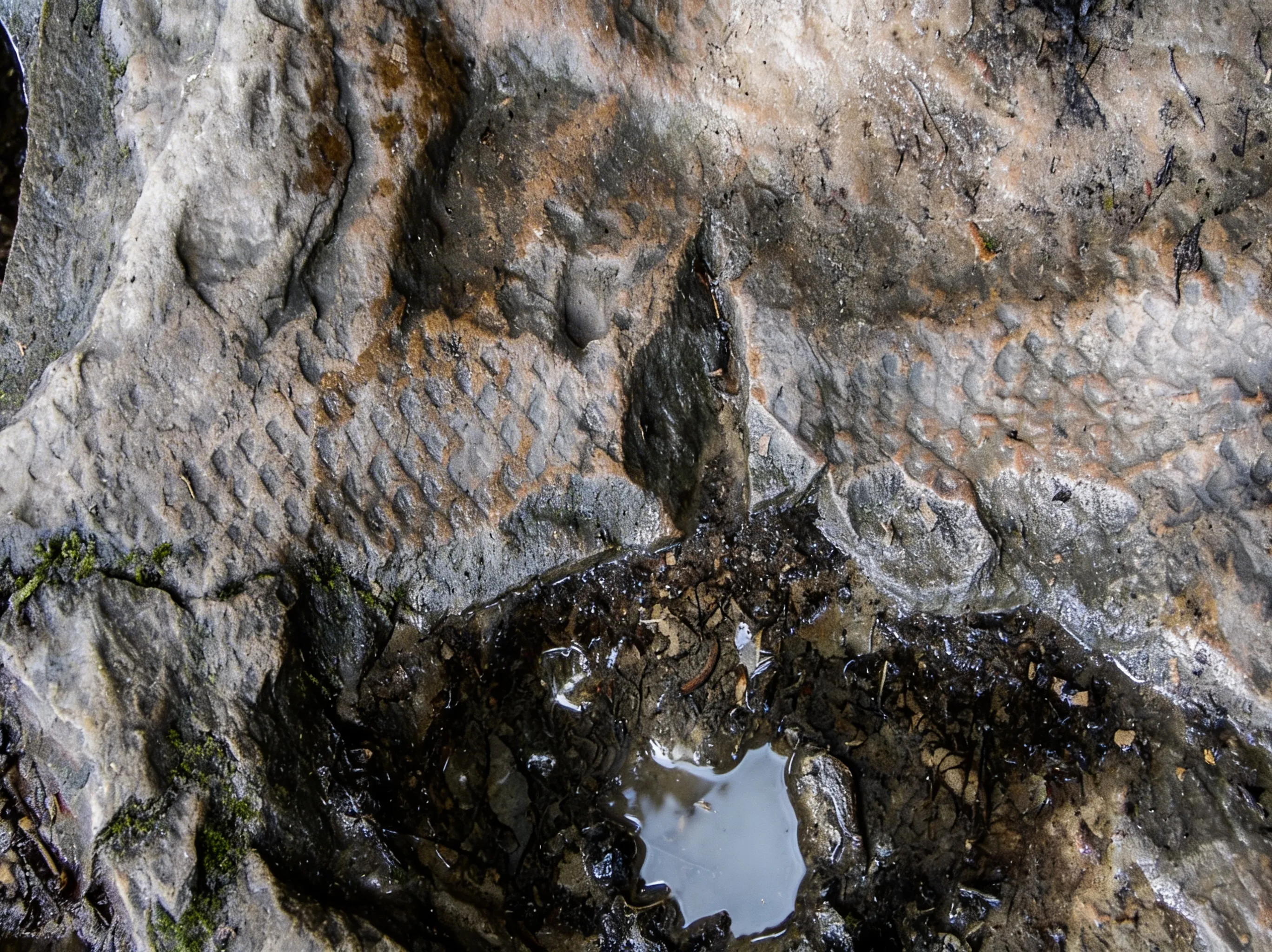 Fossil of Lepidodendron, a Carboniferous tree that resembled snake skin.
⚠️ Fossil Etiquette: This is a National Natural Landmark. Looking and photographing is encouraged. Removing fossils is illegal and damages the site for everyone else.
The Botanical Anomaly
The Youghiogheny River flows north here, forming a tight horseshoe bend around the peninsula. This bend acts like a catcher’s mitt for seeds washing down from West Virginia and Maryland. As a result, Ferncliff hosts plant species that are rare or completely absent elsewhere in Pennsylvania. The old-growth forest includes towering hemlocks, white pines, and giant oaks. Wildlife such as deer, hawks, and songbirds are commonly spotted along the trail.
The Trail (What to Expect)
The Loop (2 Miles)
The trail follows the perimeter of the peninsula. It’s mostly flat (minimal elevation change), but don’t let the “easy” rating fool you - it can be rocky and rooty in spots.
- Route: Start at the Ferncliff parking lot → follow the trail clockwise along the river → stop at Washington’s Overlook and Lovers Leap for views → loop back on the inland side.
- Time: 1-1.5 hours if you’re stopping to look for fossils.
Fossil Hunting
The best fossil exposures are on the flat sandstone ledges near the water’s edge. They are easiest to see when the rock is wet (bring a water bottle to splash them) or in the low-angle light of early morning or late afternoon.
Ohiopyle Falls Views
While the main Visitor Center overlook is always packed, the Ferncliff side offers a quieter, often superior view of Ohiopyle Falls. You can get right up to the lip of the falls on this side.
Parking & Logistics
Ferncliff Parking Lot
There is a dedicated dirt lot for the Ferncliff Natural Area located just across the bridge from the main falls area. It fills up on summer weekends but is generally less chaotic than the main falls lot or Cucumber Falls.
Alternative: Park in Town
Park in Ohiopyle town and walk across the GAP bridge (the high bridge). It adds about 0.5 miles to your hike but gives you a great aerial view of the peninsula before you start.
Safety & Hazards
River Danger
The Youghiogheny River is powerful here. The “Loop” rapids surround the peninsula.
⚠️ Warning: Stay off wet rocks near the water’s edge. The current is swift and the rocks are ice-slick.
Best Time to Visit
- Spring (April-May): Wildflowers are peaking, and the river is high (dramatic photos).
- Early Summer (June): Rhododendrons and Mountain Laurel are in bloom, turning the trail into a flower tunnel.
- Fall (October): The foliage against the dark river water is world-class.
FAQ
Where exactly are the fossils? Look for the flat sandstone ledges on the river’s edge, particularly on the downstream side of the peninsula loop.
Is the trail paved? No. It is a dirt singletrack with rocks and roots.
Can I swim here? No. The currents around the peninsula are dangerous whitewater rapids.
Is it dog-friendly? Yes, dogs are allowed on leash.
Explore More
- Ohiopyle State Park hub page
- Laurel Highlands region guide
- Cucumber Falls (nearby)

Oscar
Staff Writer
So glad you're here! I'm a lifelong hiker. The trails of this state have shaped who I am — from the waterfalls of the Poconos to the ridgelines of the Laurel Highlands — and in 2024 I started HikingPA to help more people discover what's out there. Whether you're planning your first hike, chasing waterfalls, or just looking for your next adventure in the Keystone State, I hope this becomes the resource you turn to. Thanks for being part of this community — I can't wait to explore Pennsylvania together.