Mount Tammany Loop: The Parking Lottery
Red Dot scramble, Blue Blaze descent, and the parking strategy. Here's how to hike Mount Tammany in the Delaware Water Gap.
Quick Facts
- Distance: ~3.5 miles (loop)
- Elevation Gain: ~1,200 feet
- Difficulty: Hard / Strenuous
- Time: 2-4 hours
- Best For: Experienced hikers, view chasers
- Warnings: Parking fills early, rock scramble, copperheads/rattlesnakes
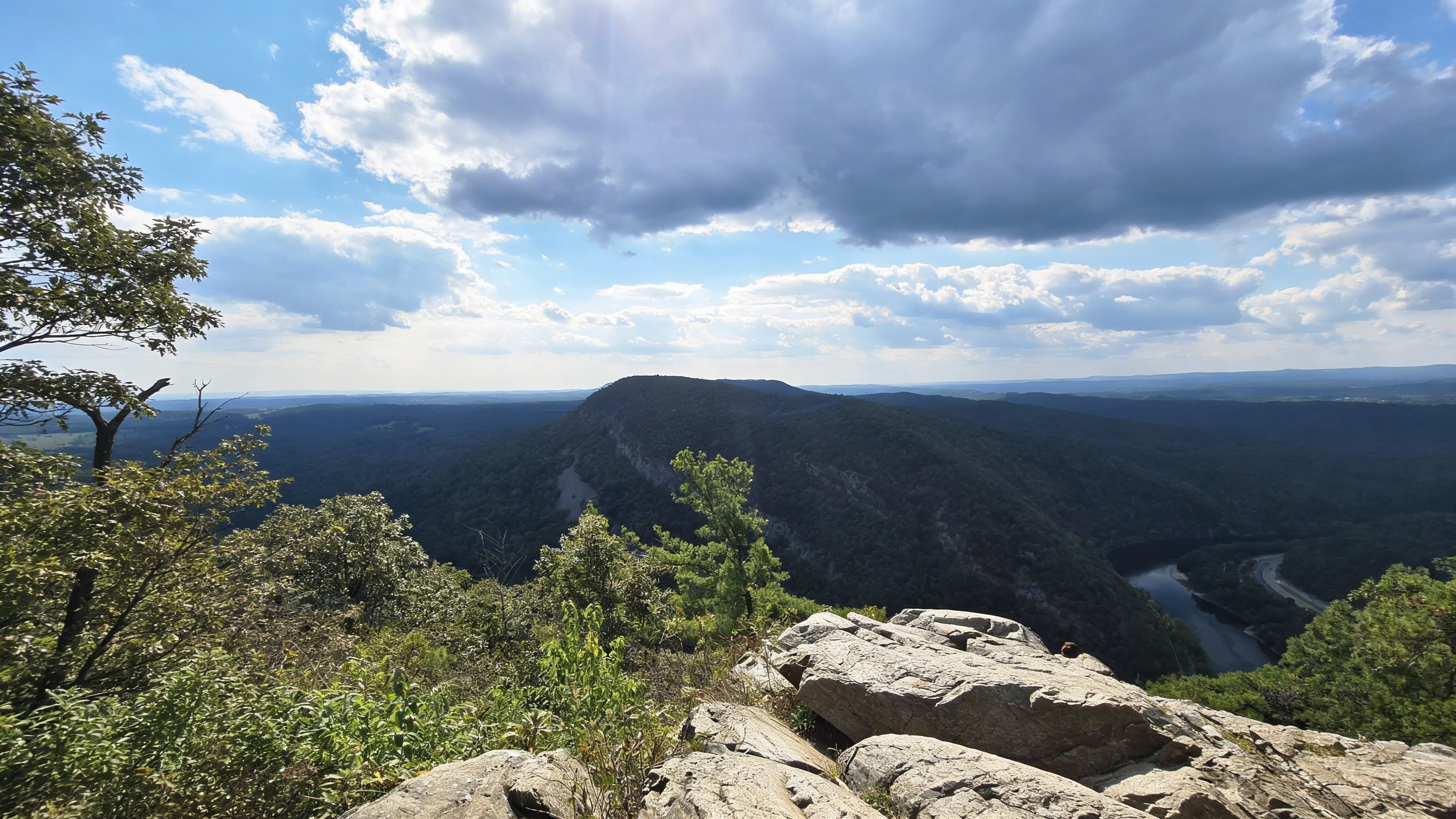
Mount Tammany is the most popular hike in the Delaware Water Gap. The view from the summit is one of the best in NJ/PA - you see the Delaware River, Mount Minsi across the gap, and I-80 winding through the valley. The hike is 3.5 miles with 1,200 feet of elevation gain. The Red Dot Trail is a steep rock scramble. The Blue Dot Trail is the gentle descent. But here’s the problem: the Dunnfield Creek parking lot fills by 8:30 AM on weekends. If you arrive at 9, you’re parking at the overflow lot and walking 15 minutes under I-80 just to start your hike. Don’t park on the I-80 shoulder - you’ll be towed. This is the parking lottery. Here’s how to win it.
Located in Delaware Water Gap National Recreation Area, Mount Tammany is on the New Jersey side of the gap. For current trail conditions, check AllTrails.
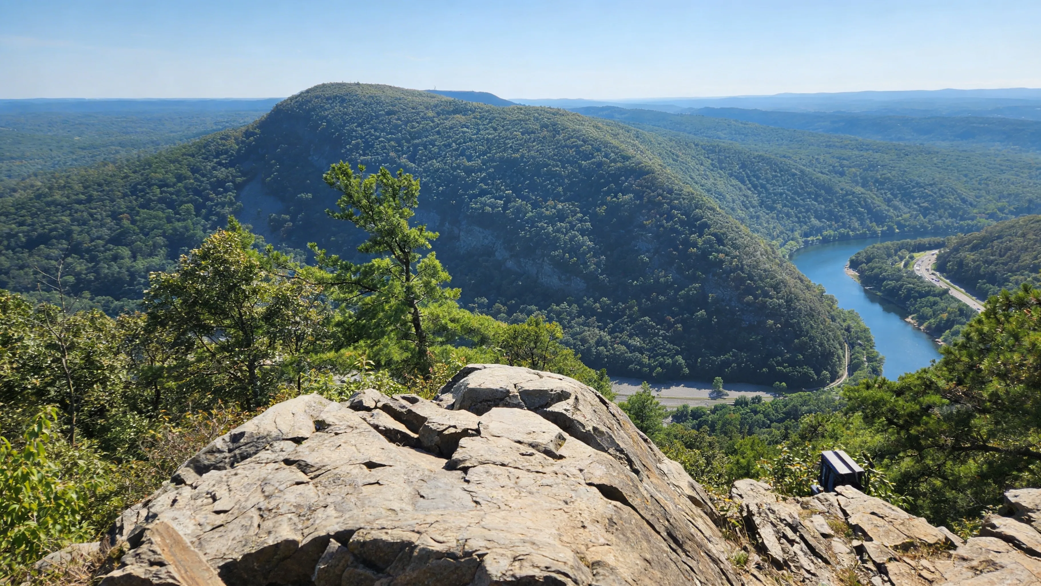 The summit offers one of the best views in NJ/PA
The Parking Situation (Plan This First)
Dunnfield Creek Lot (The Main Lot)
- Location: Off I-80 westbound, Dunnfield Creek/Appalachian Trail exit.
- Capacity: Fills by 8:30 AM on weekends, especially during warm weather and peak foliage.
- Strategy: Arrive before 8 AM or after 3 PM.
Overflow Parking (Kittatinny Point Visitor Center)
- Location: Under I-80, approximately a 15-minute walk to the trailhead.
- When to Use: If the Dunnfield Creek lot is full.
- Note: The Visitor Center itself may be closed due to staffing issues, but the parking lot remains accessible.
What NOT to Do
⚠️ Warning: Do NOT park on the I-80 shoulder or grass.
You will be ticketed ($55+) and towed ($75+ plus impound fees). State Troopers patrol this area heavily on weekends.
Shuttle Option
The Water Gap Hiker Shuttle runs seasonally on select holiday weekends. Check gomcta.com for current schedules.
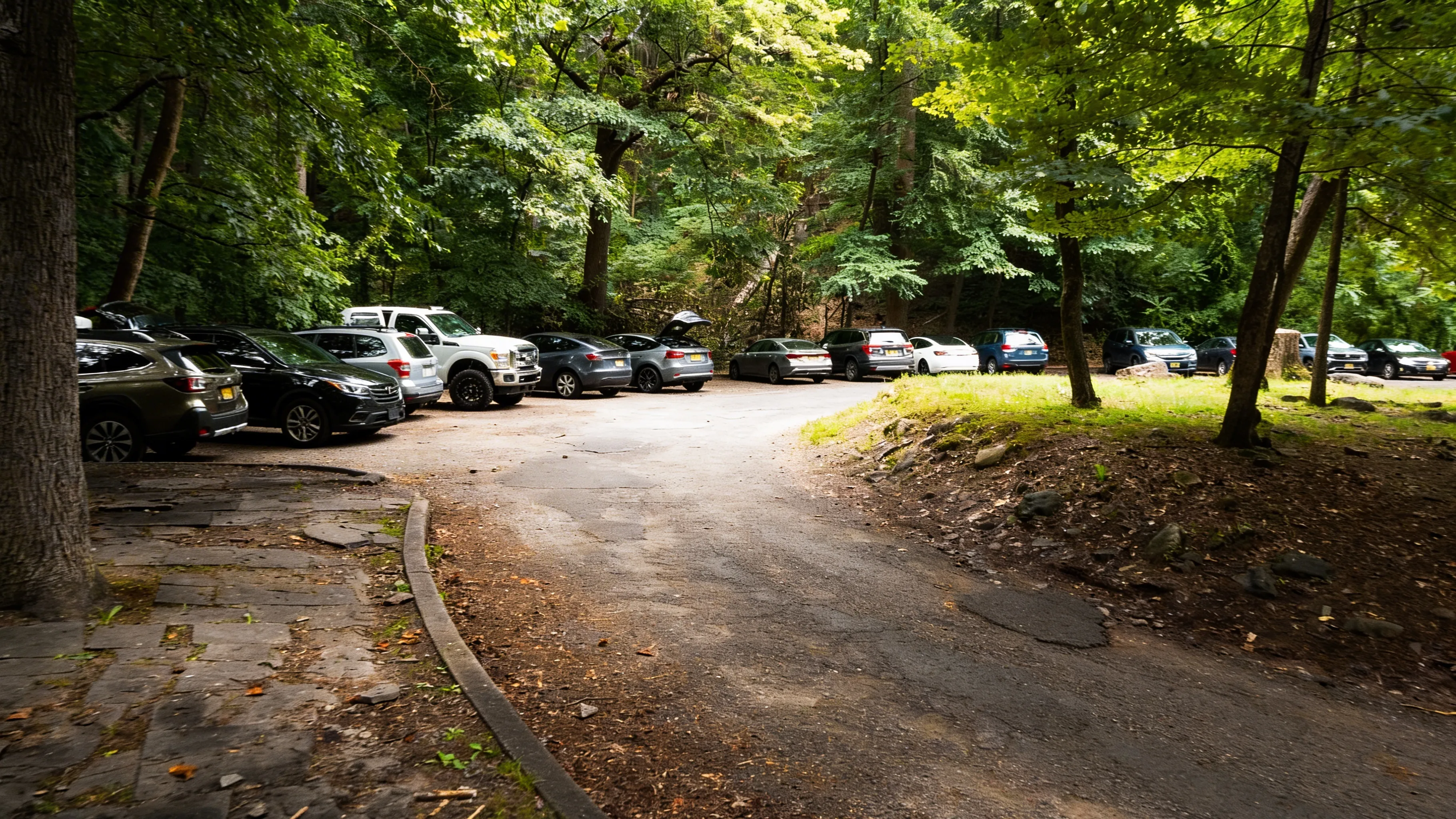 The lot fills by 8:30 AM on weekends
The Route (Up Red Dot, Down Blue Blaze)
Why This Direction?
- Up Red Dot: It’s steep, but manageable on fresh legs. The rock scramble is fun when you’re not tired.
- Down Blue Dot: It’s a gradual descent on a wider trail, which is much easier on your knees.
- Don’t Go Down Red Dot: Descending the steep, rocky sections is hard on your knees and dangerous when your legs are shaky.
Red Dot Trail (The Ascent)
- Distance: ~1.2 miles to the summit.
- Elevation Gain: 1,200 feet (rapid gain).
- Features: Rock scrambling (requires 3 points of contact in spots) and panoramic views as you climb.
- Vibe: A serious cardio workout. Expect it to be crowded on weekends.
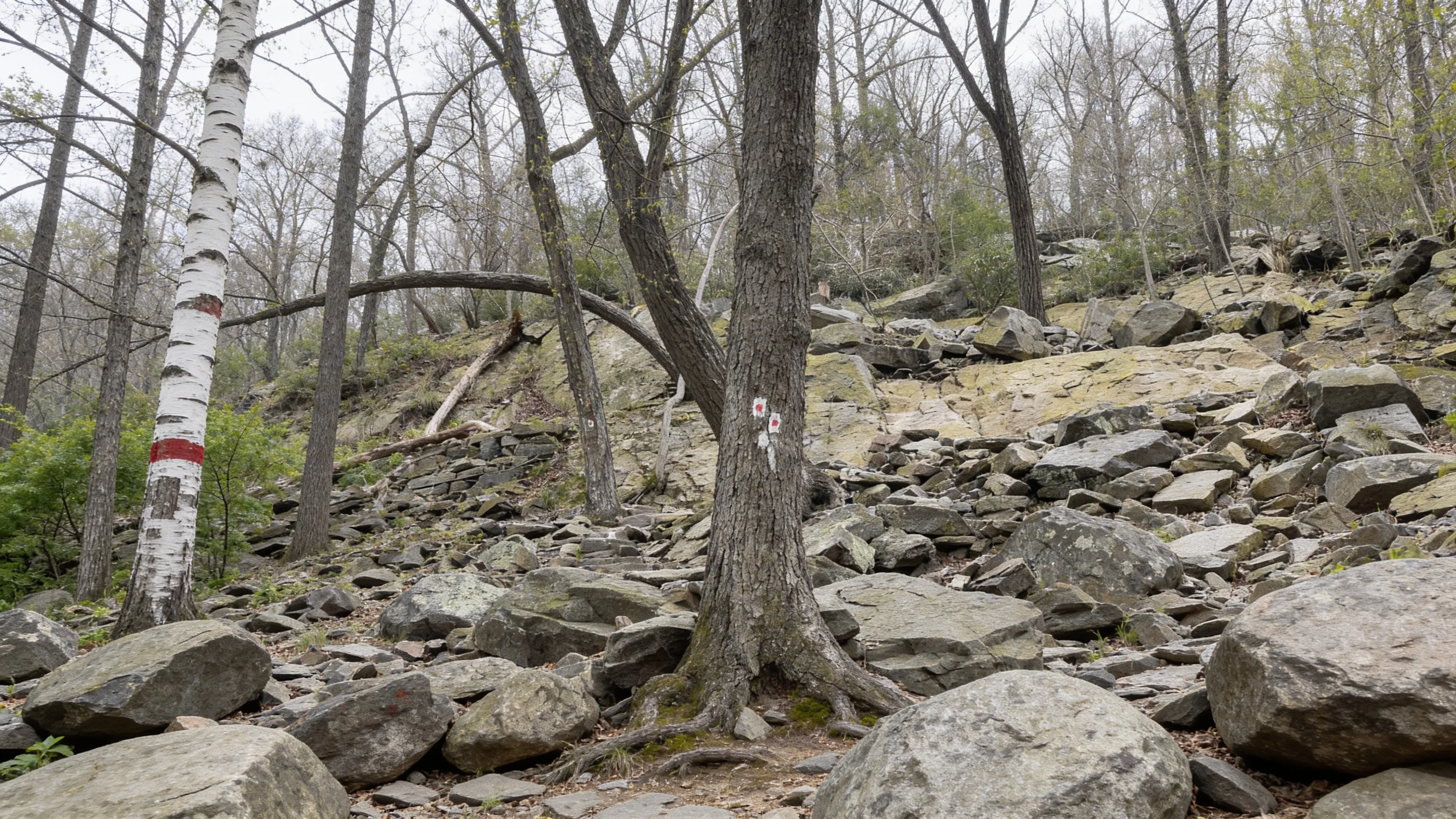 The Red Dot scramble requires 3 points of contact
The Summit
The view overlooks the S-curve of the Delaware River, Mount Minsi on the Pennsylvania side, and I-80 winding through the gap. It is widely considered one of the best views in the NJ/PA region.
Blue Dot Trail / Pahaquarry Trail (The Descent)
- Distance: ~2 miles back to the trailhead.
- Features: A dirt path that is wider, shaded, and offers access to Dunnfield Creek swimming holes near the bottom.
- Vibe: A knee-saver and a relaxing finish to the loop.
The Rock Scramble (What to Expect)
Difficulty Level
- Not Technical Climbing: You don’t need ropes, but you will use your hands.
- 3 Points of Contact: Required in some spots (two hands, one foot or two feet, one hand).
- Slippery When Wet: Avoid this trail after rain.
Fitness Level Required
- Cardio: You are gaining 1,200 feet in just 1.5 miles. It is steep.
- Upper Body: You will need to do some pulling and pushing on rocks.
- Not for Beginners: If you have never done a scramble, this is not the place to start.
Dogs on Mount Tammany
Are Dogs Allowed?
Yes, dogs are allowed on a 6-foot leash.
Can Your Dog Handle It?
- Red Dot Scramble: This can be tough for small or older dogs. You may need to lift or assist them over rocks.
- Blue Dot: This trail is much friendlier for dogs (wider, less rocky).
- Recommendation: If your dog struggles with stairs or uneven terrain, skip this hike.
Safety
Slippery Rocks
The Red Dot Trail is rocky. When wet, those rocks become extremely slippery. Avoid this hike during or immediately after rain.
Copperheads & Rattlesnakes
The sunny, rocky outcrops are prime snake habitat. Watch where you put your hands during the scramble and where you step at the summit.
Crowds
Weekends are packed. Locals call it the “Times Square of Hiking.” If you want solitude, go on a weekday or at sunrise.
Logistics
Best Time to Visit
- Spring (April-May): Cooler temps and fewer crowds.
- Summer: Hot and crowded, but the swimming holes in Dunnfield Creek are refreshing.
- Fall (September-October): Peak foliage means peak crowds. Arrive by 7:30 AM.
- Winter: Often icy and dangerous. Not recommended without microspikes/crampons.
What to Bring
- Water: At least 1 liter per person.
- Snacks: You will burn calories on the scramble.
- Gloves (optional): Helpful for protecting hands on the rock scramble.
- Sturdy Boots: Required. No sneakers or flip-flops.
Swimming
Dunnfield Creek (near the bottom of the Blue Blaze Trail) has small pools perfect for cooling off after the hike.
FAQ
When should I arrive for parking? Before 8 AM on weekends. After 3 PM is also an option, but be mindful of sunset times.
Which direction should I hike the loop? Up Red Dot, down Blue Dot. Going down Red Dot is brutal on your knees.
How hard is the Red Dot scramble? It’s steep and rocky. You will use your hands. It’s not technical climbing, but it’s a step above a normal hike.
Can I bring my dog? Yes, on a 6-foot leash. However, the Red Dot scramble can be challenging for small or older dogs.
Is there a shuttle? Yes, the Water Gap Hiker Shuttle runs seasonally on select holiday weekends. Check gomcta.com.
What if I can’t find parking? Park at the Kittatinny Point Visitor Center (overflow lot). It’s a 15-minute walk to the trailhead.
Explore More
- Check out the full Delaware Water Gap National Recreation Area guide.
- Visit the Poconos region.
- Try the Falls Trail at Ricketts Glen for another bucket-list challenge.

Oscar
Staff Writer
So glad you're here! I'm a lifelong hiker. The trails of this state have shaped who I am — from the waterfalls of the Poconos to the ridgelines of the Laurel Highlands — and in 2024 I started HikingPA to help more people discover what's out there. Whether you're planning your first hike, chasing waterfalls, or just looking for your next adventure in the Keystone State, I hope this becomes the resource you turn to. Thanks for being part of this community — I can't wait to explore Pennsylvania together.