Turkey Path: Down is Easy, Up is Hell
800 feet down into the PA Grand Canyon is easy. The climb back is brutal. Here's what to expect on the Turkey Path.
Quick Facts
- Distance: 2 miles out-and-back
- Elevation: 800 ft elevation gain (steep!)
- Difficulty: Strenuous
- Features: Waterfalls, observation decks, canyon views
- Bottom: Connects to Pine Creek Rail Trail
- Best For: Fit hikers who want to see the canyon floor
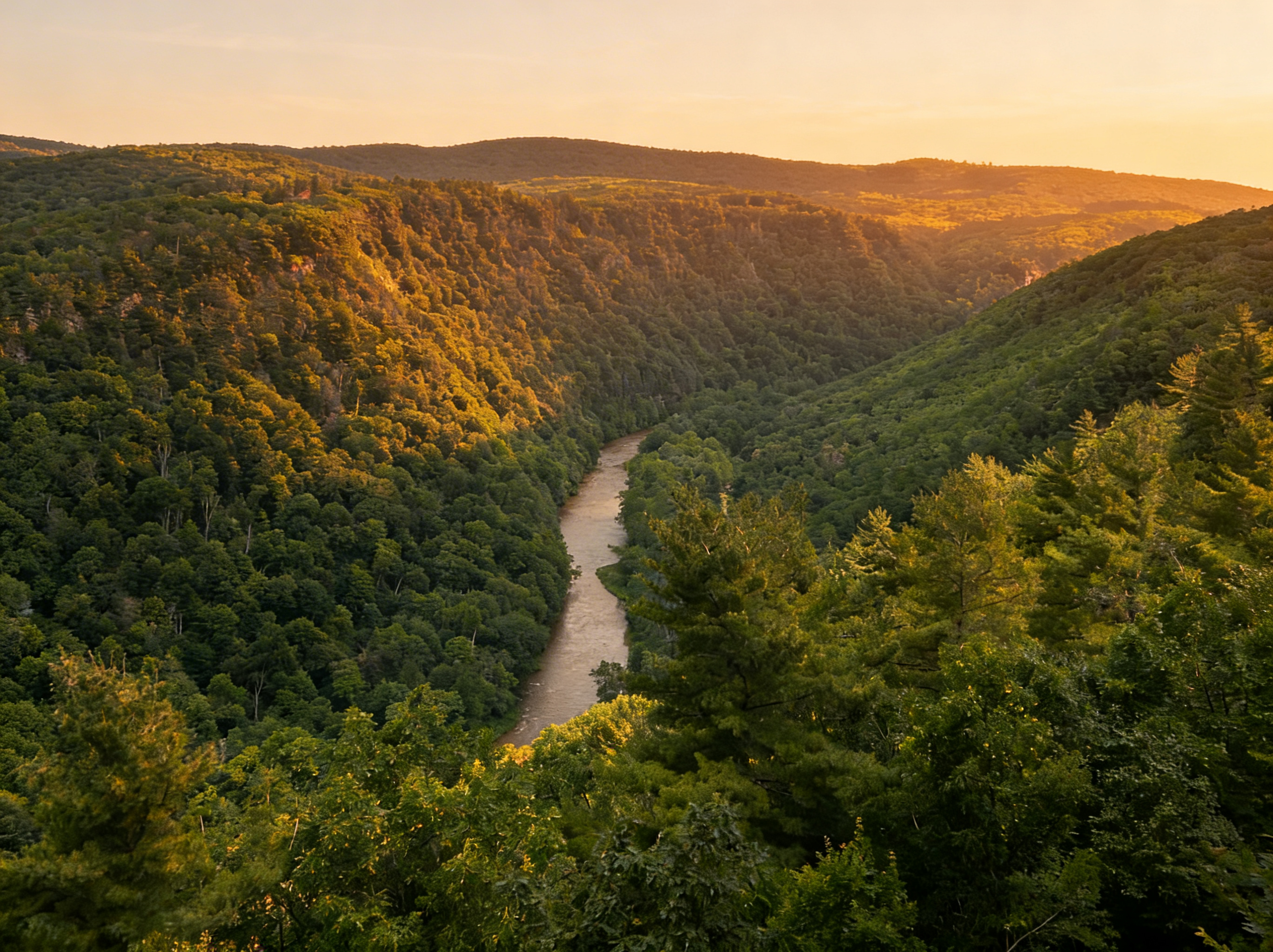
The Turkey Path at Leonard Harrison State Park is a trap. It lures you in with a deceptively easy descent on wooden decks and switchbacks, offering teasing glimpses of waterfalls. You reach the bottom, high-five at the Pine Creek Rail Trail, and look for a bridge to cross the creek. There isn’t one.
So you turn around. And that’s when it hits you: You have to climb 800 feet in one mile to get back to your car. Down is easy. Up is hell.
For current trail conditions and user reviews, check AllTrails.
Leonard Harrison vs. Colton Point (Which Turkey Path?)
There are actually two “Turkey Paths” - one on each rim of the canyon. They do not connect (unless you swim).
Leonard Harrison (East Rim) - “The Tourist Path”
This guide covers the Leonard Harrison side. It’s the popular one.
- The Vibe: Developed. Wide trails, wooden observation decks, stairs with railings.
- The Perks: Better views of waterfalls (Little Four-Mile Run), flush toilets, and a visitor center at the top.
- The Crowd: Busy. Expect to wait for photos at the waterfalls.
Colton Point (West Rim) - “The Hiker’s Path”
On the other side of the canyon is the Colton Point version.
- The Vibe: Rustic. Narrow paths, steep switchbacks, fewer railings.
- The Perks: Solitude. You’ll likely have the trail to yourself.
- The Catch: Primitive facilities (pit toilets) and the waterfalls are harder to see clearly.
⚠️ No Bridge: You cannot cross Pine Creek at the bottom to connect these trails. Do not attempt to wade across in high water - the current is stronger than it looks.
The Trail (What to Expect)
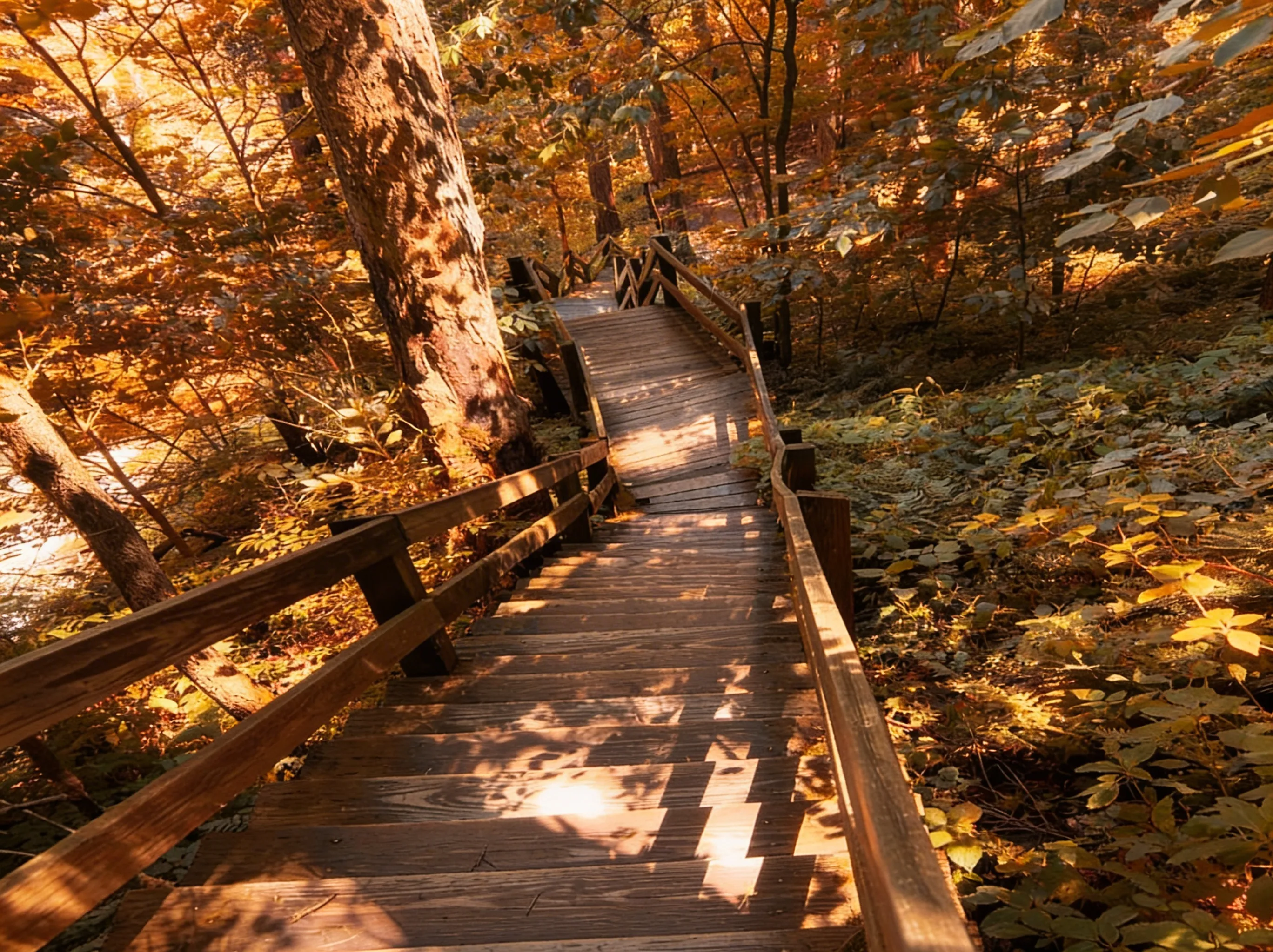
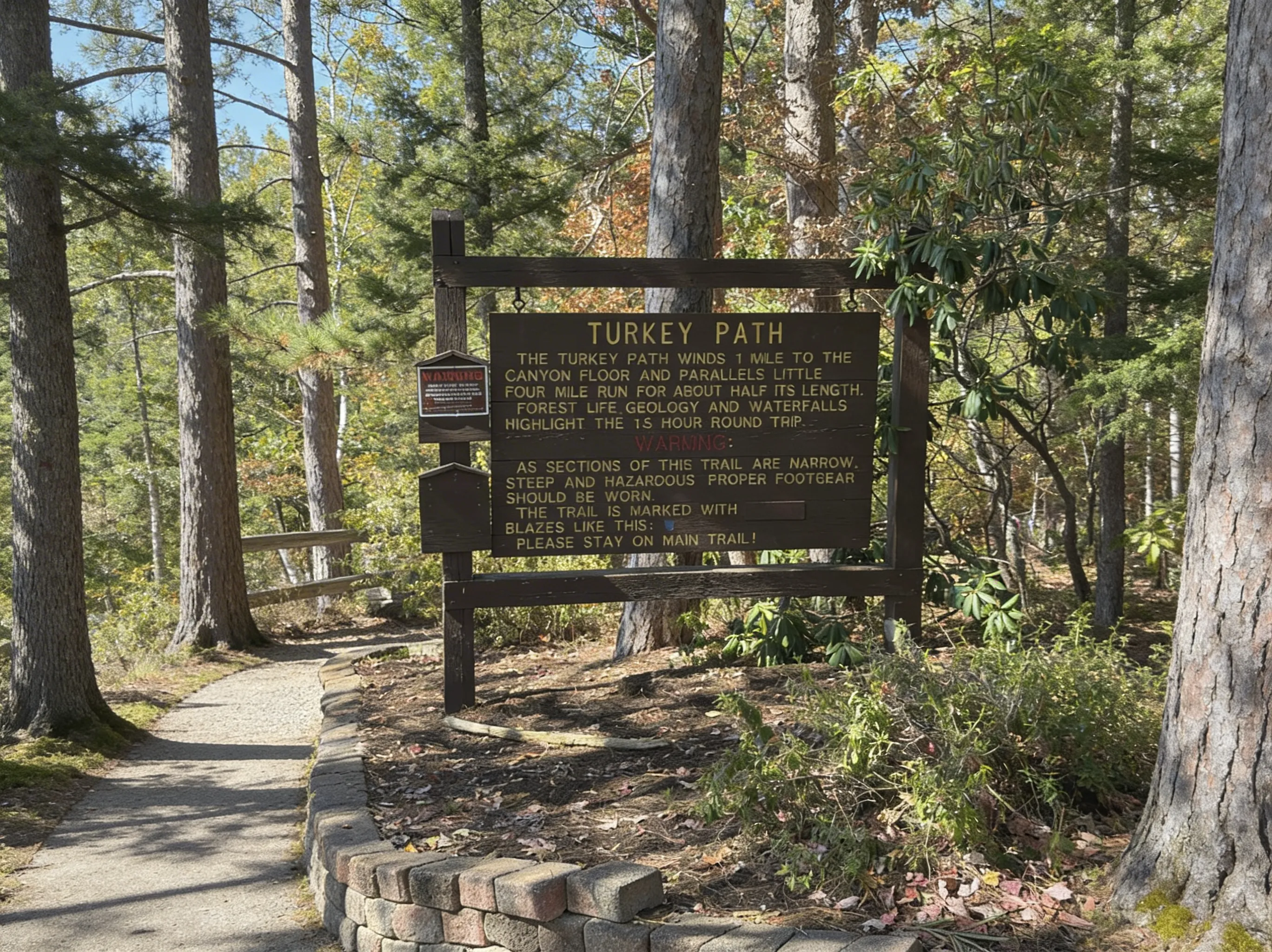
The Descent (1 Mile, 800 Feet Down)
The trail starts near the Otter View overlook. You’ll immediately begin descending on a mix of gravel switchbacks and wooden staircases. The trail is marked with yellow blazes indicating the “Most Difficult” rating. About halfway down, you meet Little Four-Mile Run. This is the scenic payoff. The trail parallels the stream, passing a series of cascading waterfalls.
- Photo Op: The wooden decks at the Upper and Lower Falls offer the best angles.
- Time: 30-45 minutes down.
The Bottom (Pine Creek Rail Trail)
The trail dumps you out onto the Pine Creek Rail Trail, the 62-mile gravel highway for cyclists. It’s flat, peaceful, and offers a great perspective looking up at the canyon walls you just descended.
- Rest Stop: There are benches here. Sit down. Drink water. You’re going to need the energy.
The Climb (1 Mile, 800 Feet Up)
This is the crux of the hike. You are gaining 800 feet of elevation in a single mile. For context, that’s like climbing the stairs of an 80-story building.
- The Strategy: Don’t sprint. Find a rhythm. Use the switchbacks to catch your breath.
- The Reality: Your quads will burn. Hikers who were laughing on the way down will be silent on the way up.
Parking & Logistics
Leonard Harrison Parking
Park in the large paved lot at the Leonard Harrison State Park entrance. It fills up fast on summer weekends and during peak fall foliage (October). If the main lot is full, overflow parking is available but adds a walk.
Trail Closures
⚠️ Warning: The Turkey Path is closed from the Wednesday before Thanksgiving until the second Friday in April due to ice (the spray from the waterfalls freezes the stairs). It also suffers from landslides. Always check the DCNR trail closures page before driving out.
Safety & Hazards
Physical Exhaustion
The #1 hazard here isn’t a cliff edge - it’s being out of shape. We see people struggling on the ascent every time we hike this. Bring more water than you think you need.
Slippery Decks
The wooden stairs and observation decks are constantly wet from waterfall spray. They can be ice-slick even in summer. Watch your step.
Timber Rattlesnakes
⚠️ Warning: Timber Rattlesnakes are present in this area, especially during warmer months (late April through September). They may come to the creek to cool down or hunt. Watch where you step and give snakes space if encountered.
Best Time to Visit
- Spring (April-May): The waterfalls are roaring from snowmelt.
- Fall (October): The “Grand Canyon of PA” is famous for its autumn colors. The climb is cooler, but the crowds are at their peak.
- Avoid: Mid-day in July. The humidity in the canyon can be stifling, making the climb out dangerous.
Explore More

Oscar
Staff Writer
So glad you're here! I'm a lifelong hiker. The trails of this state have shaped who I am — from the waterfalls of the Poconos to the ridgelines of the Laurel Highlands — and in 2024 I started HikingPA to help more people discover what's out there. Whether you're planning your first hike, chasing waterfalls, or just looking for your next adventure in the Keystone State, I hope this becomes the resource you turn to. Thanks for being part of this community — I can't wait to explore Pennsylvania together.